About Walton Manor
Conservation
Much of Walton Manor is within a Conservation Area
1. What are conservation areas?
The National Planning Policy Framework (2023) sets out the government's planning policies for England and how the local authorities are expected to enact the policies. Section 16 of the policy framework requires local authorities to designate areas of special architectural or historic interest as conservation areas. Furthermore local authorities are required to formulate and publish proposals for the preservation and enhancement of designated conservation areas in the form of area appraisals and management plans.
2. Conservation Areas in Oxford
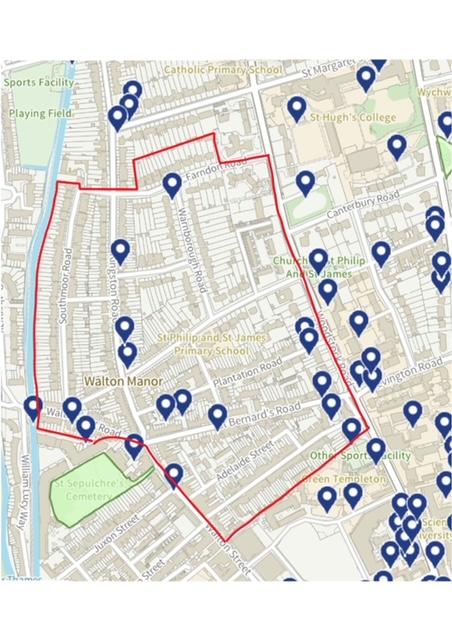
To date Oxford has designated 18 areas of the city as conservation areas. Two of these conservation areas, the North Oxford Victorian Suburb Conservation Area and the Walton Manor Conservation Area intersect with the Walton Manor Residents Association (WMRA) area (see map below). The area to the south of the WMRA area falls within the Jericho Conservation Area.
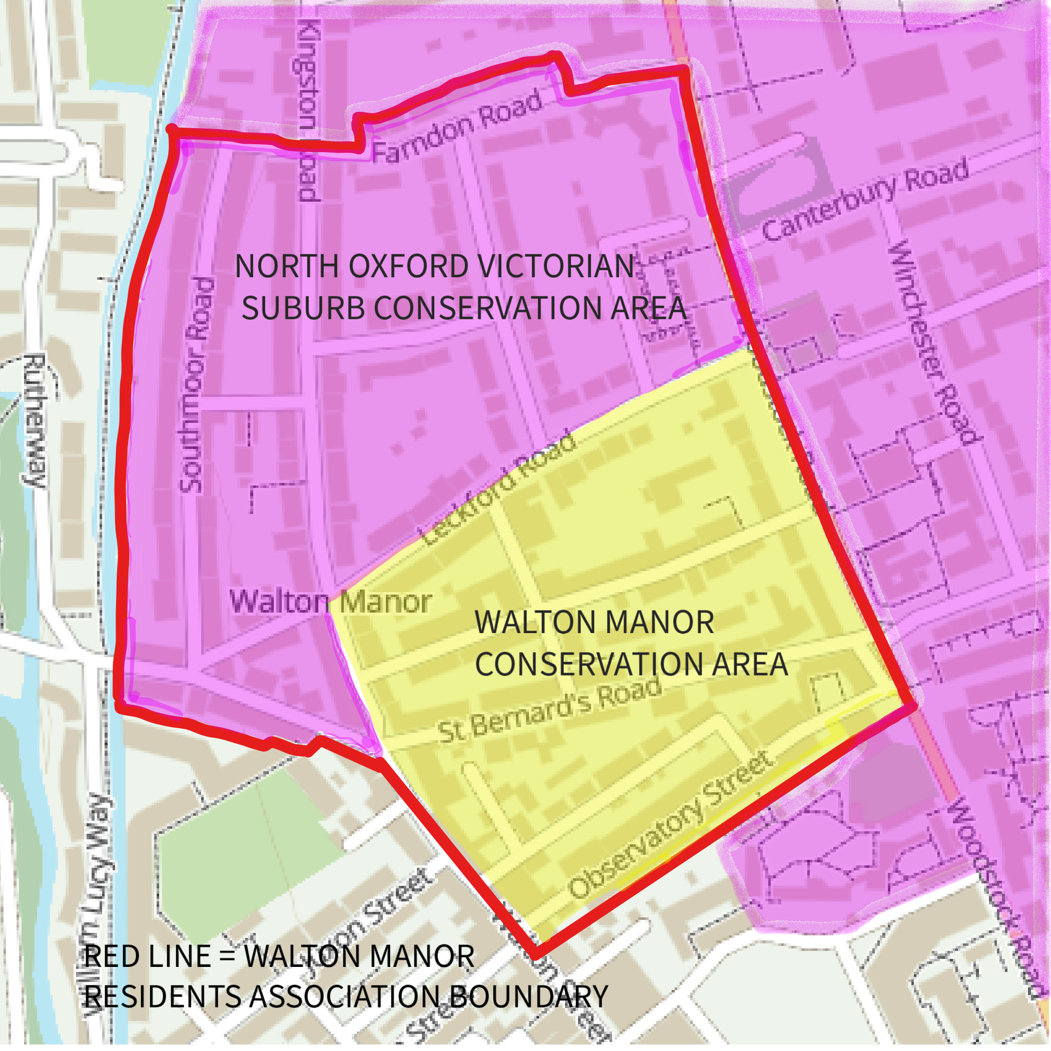
Conservation Areas within the Walton Manor Residents Association Boundary (red line)
3. North Oxford Victorian Suburb Conservation Area Appraisal and Management Plan
The North Oxford Victorian Suburb was designated a conservation area in 1965 (extended in 1972,1975) and covers a large area of North Oxford roughly between the Radcliffe Observatory in the south and Summertown in the north. Most of this area is land that St John’s College acquired in the sixteenth century and developed in the mid-late nineteenth century as a planned middle class residential suburb.
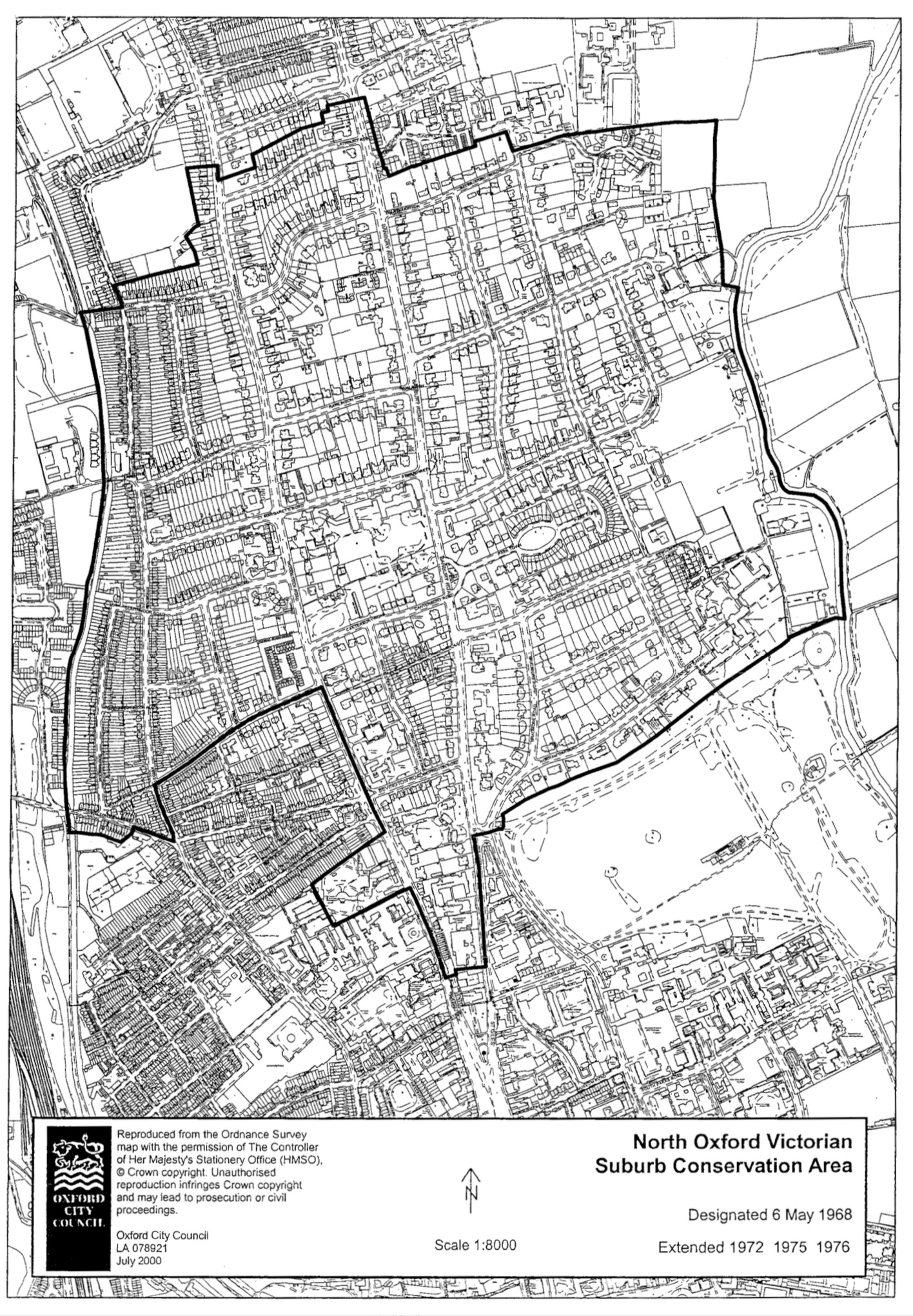
Oxford City Council’s map of the North Oxford Victorian Suburb Conservation Area (1965 - extended in 1972,1975).
The development of the area was largely overseen by the architect William Wilkinson and the high degree of control he chose to exercise via the leases resulted in a remarkably consistent suburban development of large High Victorian gothic villas to the north and east, particularly east of Woodstock Road, and smaller brick fronted terraced artisan housing to the west. The portion of the Conservation Area that falls within the WMRA area contains a mixture of small two storey artisan terraces, three storey middle class family houses and large semi-detached villas. This area was added to the existing North Oxford Conservation Area in 1975.
In 2017 Oxford City Council approved a detailed study of the Conservation Area: North Oxford Victorian Suburb Conservation Area Appraisal with a view to highlighting the distinctive urban and architectural character of the area. The appraisal covers an area much larger than Walton Manor but the section Character Area 4. Kingston Road includes a detailed description of the special urban and architectural character of the WMRA area from the north side of Leckford Road to the north side of Farndon Road. This section is well worth reading as it highlights the significance of the area, its key urban and architectural features as well as highlighting the key threats to the character of the area.
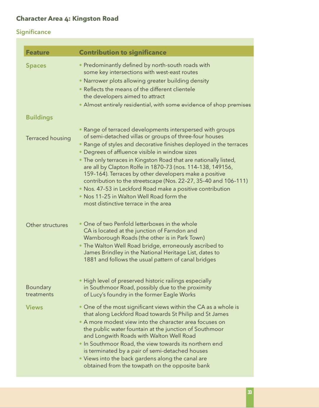
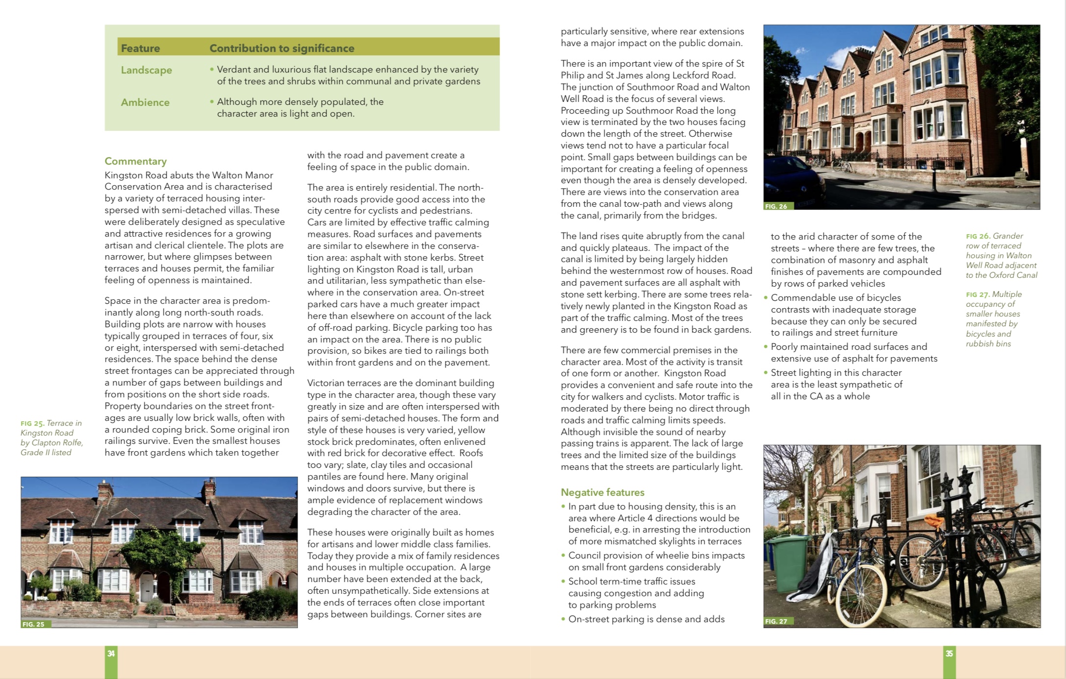
Extract from the North Oxford Victorian Suburb Conservation Area Appraisal: Character Area 4: Kingston Road (p33-35).
The appraisal also makes special mention of the iron railings and brick plinths that were once an important and distinctive feature of the North Oxford Victorian Garden Suburb. Many of the nineteenth century railings were removed during WWII and of those surviving many are in need of repair or replacement. Subsequently Oxford Preservation Trust has published a guide to the design and repair of North Oxford railings to assist residents in the repair or reinstatement of their railings.
The appraisal concludes with a section which highlights opportunities for enhancement of the Conservation Area (p49-50). Issues of particular relevance for the WMRA area are listed as:
Designation
Protection for unlisted buildings: Consideration should be given to Article 4 directions to control inappropriate development of unlisted buildings by removing certain permitted development rights, including:
Improvements in the Public Domain:
Development Management: Development Management offers the opportunity to manage change appropriately, conserve and enhance the special character of the conservation area by managing:
Management of trees: Pro-active tree management is desirable for dealing with aging trees and to encourage succession planting that will help to ensure mature tree canopy cover is sustained |
Extract from the North Oxford Victorian Suburb Conservation Area Appraisal: Opportunities for Enhancement (p49-50).
To date Oxford City Council have not published a formal management plan, with objectives, timescales and responsibilities. Therefore there is an opportunity for WMRA to work with the City Council towards the formulation of a management plan that would preserve and enhance the northern section of the WMRA area.
4. Walton Manor Conservation Area Appraisal and Management Plan
Walton Manor was designated a conservation area in 1975. This conservation area is bounded by the outer wall of the Radcliffe Observatory to the south, Leckford Road to the north, Walton Street to the west and Woodstock Road to the east (see map below). Oxford City Council’s Conservation Officer at the time drew a distinction between the Victorian Gothic of the North Oxford Conservation Area and the Georgian vernacular of this part of Walton Manor.
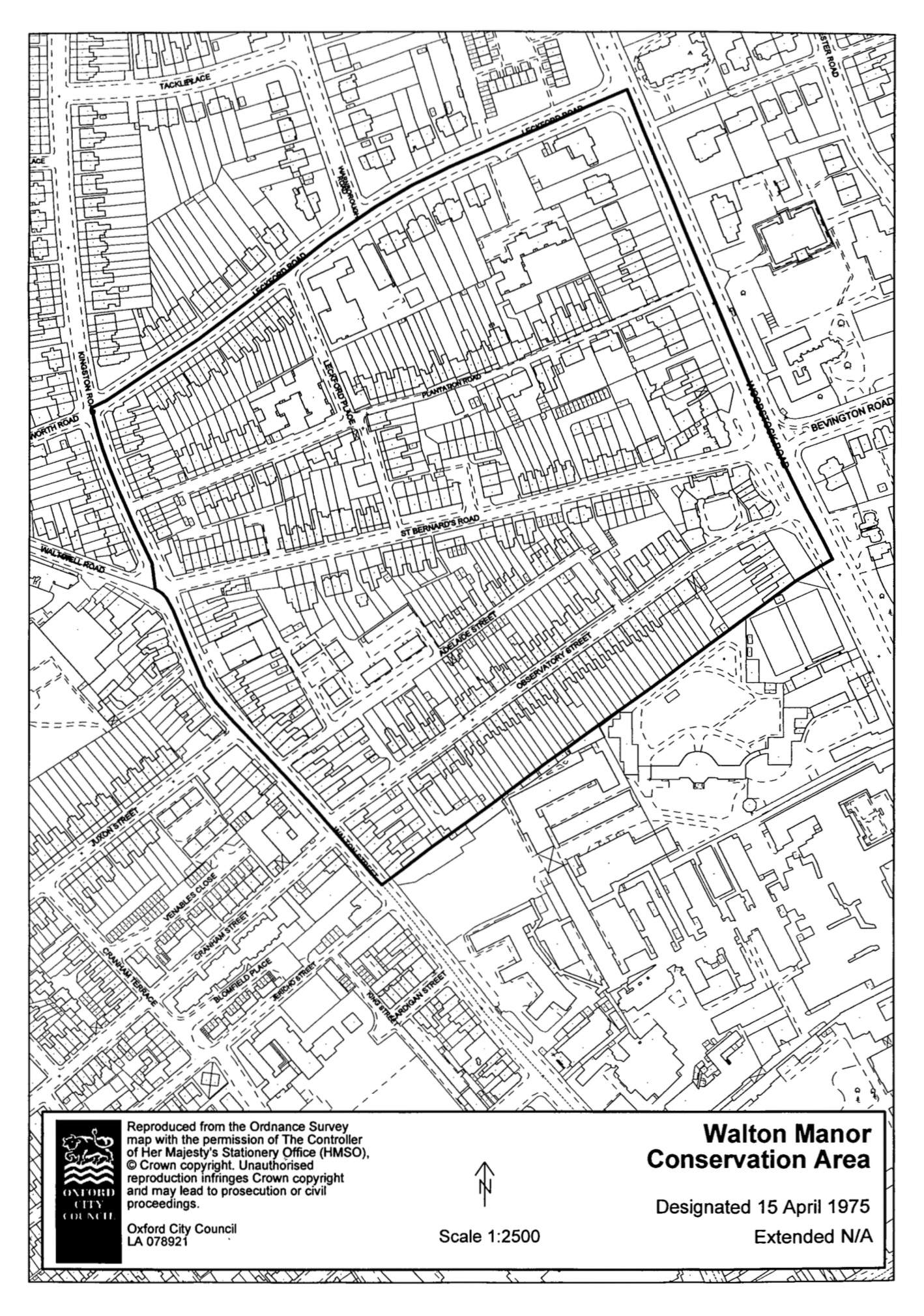
Oxford City Council’s map of Walton Manor Conservation Area (1975)
In the early nineteenth century this area was known as Tagg’s Garden. The land, which lay just outside the city boundary, was owned by St John’s College but leased to local men including Thomas Tagg, whose family were in the nursery garden business. These leaseholders in turn sublet to other tenants. The use was primarily for production of food for the Colleges and perhaps Oxford’s markets. Tanis Hinchcliffe noted in her detailed study of North Oxford that during the 1820s tenants were building cottages and other structures on Tagg’s Garden ‘so that the area was becoming more and more a working-class suburb, without any control being exerted by the college’ (p25). In 1832 the College started the process of taking back control of the use and development of this area by obtaining an Enclosure Award, subject to the leases then in place. Most of the leases expired in 1843.and the College commissioned Henry Jones Underwood to produce a plan for the development of the area, which formed the basis for the sale of twenty-year leases to builder/developers on vacant plots. Although there are a few houses that pre-date Underwood’s plan, such as the 1830s stucco terraces in Woodstock Road and Observatory Street, and the diaper (patterned) brick houses in several streets, most of the buildings were built between 1843 and 1890 by small local builders in accordance with the strict conditions set by the St John College leases.
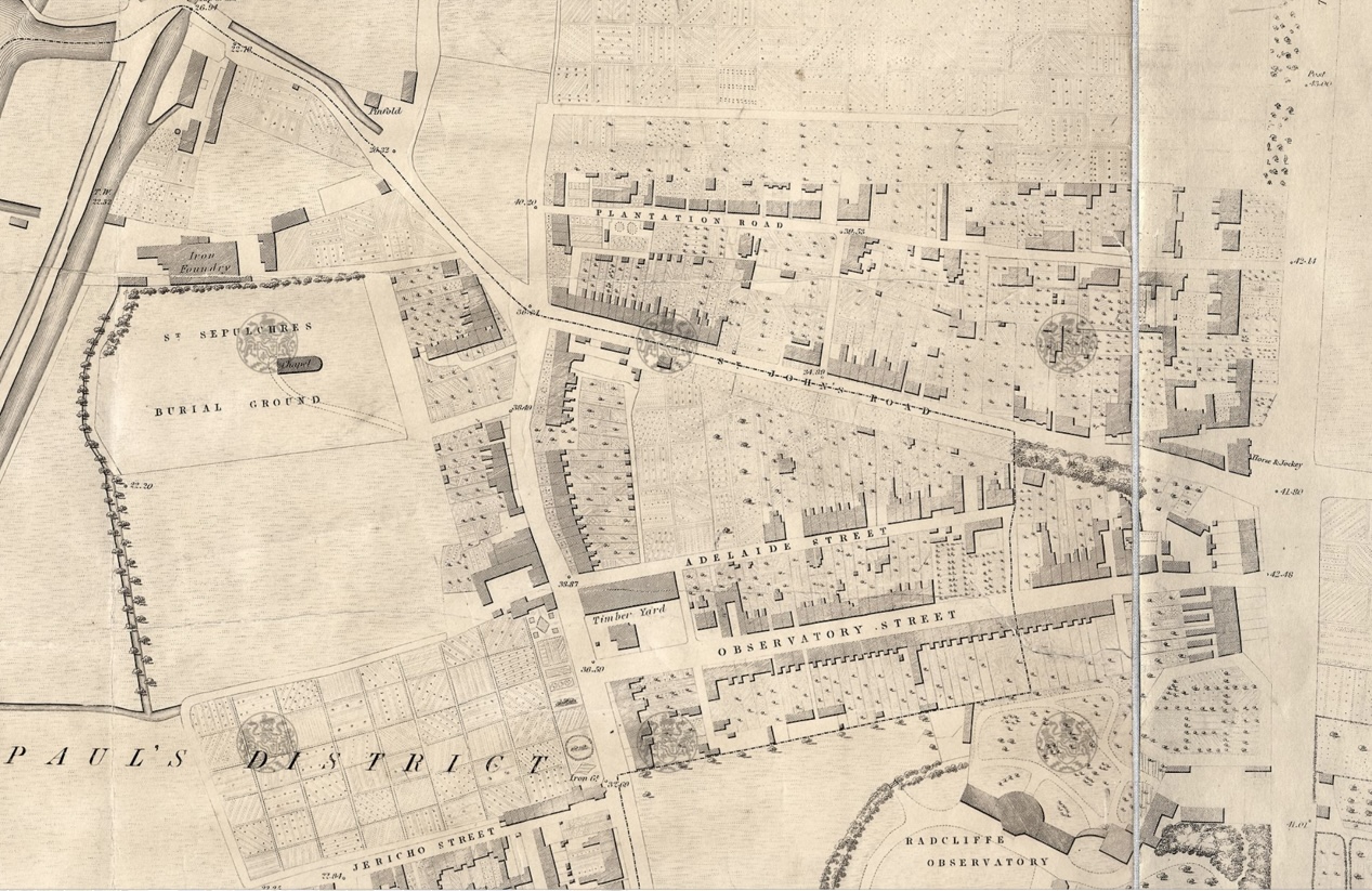
Extract from Hoggar’s Map of 1850 showing the road layout for Walton Manor in place but many building plots were still vacant (copyright Bodleian Library).
Thus developed a working class suburb of tightly packed small Victorian terraced houses that accommodated the builders, artisans, tradesmen and shopkeepers that were needed to service the burgeoning University, University Press, Radcliffe Infirmary, Railway and Eagle Ironworks, and later Oxford’s growing commercial centre. The artisan character of the area was similar to the Jericho area (although more hygienic because it was on higher ground away from the canal) but very different to the grander middle class suburbs developed to the east (Park Town and Norham Manor) and to the north (North Oxford).

Plantation Road retaining something of its past characteras a country lane.
The citation for the Walton Manor Conservation Area designation emphasizes the differences from the North Oxford Victorian Suburb: the street layout was in place by 1850; the houses and plots are generally small and the area has a human scale, with an intricate pattern of narrow streets.
The intimate character of the area remains largely intact to this day, although most of the houses are now privately owned. The mix of commercial uses within this residential area has largely disappeared since Victorian times although the two remaining pubs, The Victoria in Walton Street/St Bernard’s Road and the Gardeners Arms in Plantation Road, are an important part of the social fabric of the area.
Some 20th century intrusions have left their mark: the Grade II Listed 1930s block of shops, offices and flats at Belsyre Court on Woodstock Road, and the 1970s blocks of flats at Leckford Road (Hart-Synnot House) and Plantation Road (Wyndham House). There continues to be pressure from individual home-owners to update and extend their houses. Part of WMRA’s role is to monitor and where appropriate comment on such proposals.
To date the Walton Manor Conservation Area has not been subject to an area appraisal or management plan. However, there is a reasonable expectation that the Council will start the appraisal process in 2024. The WMRA Committee has intimated to the Council that the residents would be interested in contributing to the appraisal.
5. Bibliography
Bradley, S., Pevsner, N. and J. Sherwood (2023) Oxfordshire: Oxford and the South-East. London: Yale University Press.
Department for Levelling Up, Housing and Communities (2012) National Planning Policy Framework Section 16: Conserving and enhancing the historic environment. Available at: https://www.gov.uk/guidance/na....
English Heritage (2026) Adapting Historic Buildings for Energy and Carbon Efficiency. Historic England Advice Note 18 (HEAN 18). London: English Heritage. Available at:https://historicengland.org.uk/images-books/publications/adapting-historic-buildings-energy-carbon-efficiency-advice-note-18
Hinchcliffe, T. (1992) North Oxford New Haven, London: Yale University Press.
MacCannel, D. (2016) Oxford: Mapping the City. Edinburgh: Birlinn Ltd.
Oxford City Council (2010) Jericho Conservation Area Study. Available at: https://www.oxford.gov.uk/down....
Oxford City Council (2011) Jericho Conservation Area Area 4 Directive. Available at: https://www.oxford.gov.uk/down....
Oxford City Council (2017) North Oxford Victorian Suburb Conservation Area Appraisal. Available at: https://www.oxford.gov.uk/down....
Oxford Preservation Trust and Oxford City Council (2012) North Oxford Railings: a guide to design, repair and reinstatement. Oxford: Oxford Preservation Trust. Available at: https://www.oxford.gov.uk/down....
Tyack, G. (1998) Oxford: an architectural guide Oxford: Oxford University Press.
English Heritage (2024) Energy Efficiency and Retrofit in Historic Buildings. Available at: https://historicengland.org.uk/advice/technical-advice/retrofit-and-energy-efficiency-in-historic-buildings/
6. Listed Buildings within Walton Manor Residents Association Area
Listed Buildings within the Walton Manor Conservation Area boundary (red)
For further details of individual buildings see the Historic England Website
BELSYRE COURT, WOODSTOCK ROAD: Listed Building Grade: II. List Entry Number: 1392939.
HOLYFIELD HOUSE, 1 WALTON WELL ROAD: Listed Building Grade: II. List Entry Number: 1392943
114-138, KINGSTON ROAD : Listed Building Grade: II. List Entry Number: 1332959
149-156, KINGSTON ROAD : Listed Building Grade: II. List Entry Number: 1369384
159-164, KINGSTON ROAD : Listed Building Grade: II. List Entry Number: 1047245
OXFORD CANAL ROAD BRIDGE (242) : Listed Building Grade: II. List Entry Number: 1369698
2-14, PLANTATION ROAD : Listed Building Grade: II. List Entry Number: 1392948
16-18, PLANTATION ROAD : Listed Building Grade: II. List Entry Number: 1392935
28-31, ST BERNARD’S ROAD : Listed Building Grade: II. List Entry Number: 1392936
11-25, WALTON WELL ROAD : Listed Building Grade: II. List Entry Number: 1392944
96-101, WALTON STREET : Listed Building Grade: II. List Entry Number: 1392942
WALTON WELL DRINKING FOUNTAIN, WALTON WELL ROAD : Listed Building Grade: II. List Entry Number: 1047105
LETTERBOX ON CORNER OF WARNBOROUGH ROAD: Listed Building Grade: II. List Entry Number: 1047298
45-55, WOODSTOCK ROAD : Listed Building Grade: II. List Entry Number: 1047071
71-79, WOODSTOCK ROAD : Listed Building Grade: II. List Entry Number: 1372273
91, WOODSTOCK ROAD : Listed Building Grade: II. List Entry Number: List Entry Number: 1369465
93-97, WOODSTOCK ROAD : Listed Building Grade: II. List Entry Number: 1047072