About Walton Manor
North Oxford & The Railways
The Railway Companies’ battle to expand their network to Oxford, and the social consequences for the City of their eventual success, have been well described elsewhere. This overview will show how the development of the railways affected North Oxford, and Walton Manor in particular, and especially what might have happened. The area could have been very different from how we perceive it now. Some of the historical material also sheds a light on the progression of the development of this area for housing.
The plethora of railway companies and schemes for which Parliamentary approval was sought - reaching a peak of over 700 nationally in the 1846-47 session- is complicated and confusing. Many proposals either were not approved, or could not raise enough finance to proceed, but the information filed in support of the applications, or opposition to them, can still add some information not otherwise available to us. In particular, the “Deposited Plans” and “Book of Reference” provide a snapshot of the ownership, occupation and use of each numbered plot within the “Limits of Deviation” which frame each of the proposals.
As most people know, Stephenson’s “Rocket” was the first practical steam locomotive, built for the Stockton and Darlington Railway. The first commercial public steam-powered railway was the Liverpool and Manchester Railway, opened in 1830.
The railway system developed rapidly from then on, with entrepreneurs, financiers and investors competing through private companies which sought approval to build and operate rail lines from Parliament in the form of Private Bills. Much of the commercial impetus for developing these railways was to service bulk freight- coal, iron, wheat, bricks, gravel etc- supporting the rapid industrialisation of Britain by enabling much quicker and cheaper movement of such materials, in larger quantities, than the canal or road systems allowed. The advantage of speed also encouraged the use of the new railways for the Royal Mail and perishable goods such as milk.
As well as financial competition, the technologies of broad and narrow gauge competed for dominance. Simplistically, narrow gauge (4ft 8 1/2 inches) was cheaper to build- it used less land-but broad gauge (7ft 1 1/4 inches) was better able to cope with higher volumes and speed of trains. Brunel’s Great Western line from London to Bristol via Didcot and Swindon, opened in 1841, was broad gauge but most other lines built in the 1830s and 1840s, notably the London to Birmingham route which later became the London and North Western Railway were narrow gauge and from 1846 that became the standard. The GWR suffered a long changeover including an interim “mixed gauge” solution with a third rail and was not completely converted until 1892.
The various railway companies that remained independent were forcibly grouped by the Railways Act 1921 from 1923, still as private companies, and then nationalised from 1 January 1948 by the Transport Act 1947, as part of the British Transport Commission. This became the British Railways Board from 1 January 1963 and then British Rail until privatised in 2001.
Despite Oxford’s central position, vested interests there, both town and gown, resisted schemes for connecting Oxford to the rest of the network in 1836, 1838 and 1840 and it was not until 1843 that the Oxford Railway Company, backed by the GWR, finally obtained Parliamentary approval for a link from Didcot. That line, to a station in Grandpont south of Folly Bridge, opened for both passengers and freight on 12 June 1844.
The Oxford and Rugby Railway Company was then formed by GWR and authorised in 1845 to construct a (broad gauge) line north from Oxford via Banbury, to connect with the (narrow gauge) London and North-Western Railway at Rugby. However, the GWR thought again and, through the Birmingham and Oxford Railway Company, obtained powers in 1846 to construct its own line direct to Birmingham via Leamington. The two schemes were combined to create the Oxford to Birmingham line, as mixed or dual gauge. The first section from Oxford to Banbury opened on 2 September 1850 and the full route opened on 1 October 1852, as did the new GWR station next to Botley Road, where the current station is now.
This section of railway is of course the one which still runs to the west of the Oxford Canal alongside what is now Jericho and North Oxford, separating the Oxford Canal from Port Meadow and the Thames. At this time the land between the canal and the Banbury Road north of the Observatory and Plantation Road was used as market gardens with a few isolated buildings. The main industrial uses were alongside the canal, including Lucy’s Ironworks and a tallow works.
While the GWR was focussed on going north to Birmingham, the Oxford Worcester and Wolverhampton Railway Company (the OWW), obtained powers in 1845 to go further west to Worcester and thence to the industrial heartland of Wolverhampton, meeting the GWR line by a junction at Wolvercote. This line opened in 1853 and was leased to and operated by GWR. The OWW and the GWR agreed to cooperate in operating the OWW services into and out of Oxford, using the GWR station and their lines to the north of Oxford. The OWW was built as mixed gauge rather than broad gauge. The OWW suffered a large cost overrun during its construction (for the full story including the Campden Tunnel debacle see The Oxford, Worcester and Wolverhampton Railway by John Boynton,2002) and struggled thereafter. It became known locally as “The Old Worse and Worse”.
In 1860 it merged with the Worcester and Hereford Railway and the Newport, Abergavenny and Hereford Railway to form the West Midland Railway which in turn was swallowed up by the GWR in 1863.
This line did not directly impact on North Oxford as it used the existing GWR lines into Oxford although it was connected to the BRC (later LNWR) lines to Bletchley and Cambridge at Yarnton. It still operates to Worcester and Great Malvern but not Wolverhampton.
The OWW put forward more ambitious plans-breaking away from the GWR- to take their line into North Oxford and then into London in 1851/1852, which did not succeed in getting Parliamentary approval. If those proposals had been approved and built, North Oxford would have been very different today. Those proposals are described later.
The third promoter of railway schemes in Oxford was the Buckinghamshire Railway Company (the BRC), a combination between the Buckingham and Brackley Junction Railway Company and the Oxford and Bletchley Railway Company. Their proposal was to create a (narrow gauge) cross-country route between Oxford, the London and North-Western Railway main line (from Euston) at Bletchley, the Midland mainline (from St Pancras) at Bedford and the Great Eastern (from Kings Cross) at Cambridge. The BRC obtained the necessary Parliamentary powers for the first phase from Bletchley to Oxford and Banbury in 1847 and the Oxford section opened on 20 May 1851.
Rather than connect into and share facilities at the GWR’s Oxford station, the BRC chose to build a new station on the derelict site where Rewley Abbey once stood, to the east of the GWR station. Rewley Abbey had been a Cistercian monastery founded around 1287 but closed in 1539 as part of the dissolution of the monasteries by Henry VIII. This new station was for both freight and passenger traffic, and later became known as the Varsity Line due to the link it established between the two university cities.
One side-effect of this line was the use of the gravel within the former Cabbage Hill, a large mound at the western end of Plantation Road, as ballast for the new line, which created the opportunity for the realignment of the track leading north from Walton Well to the Aristotle Lane canal bridge which later became Kingston Road.
The rail access to the new BRC terminus crossed the Sheepwash Channel linking the Oxford Canal to the Thames by a swing bridge -now a Scheduled Ancient Monument which has recently been restored by the Oxford Preservation Trust. This line closed to passenger traffic on 30 December 1967 following the Beeching strategic review but continued to be used for carriage of coal into Oxford, and distribution of bricks from the brickworks in Bedfordshire. The station itself finally closed down in 1984 and the site is now the Said Business School. The line and sidings immediately to the north have now been redeveloped for housing.
The reversal of Beeching’s closure started in 1987 with an experimental service between Oxford and Bicester Town station, which became permanent in 1989. After the formation of Chiltern Railways in 2011, the line from Oxford to Bicester was upgraded to double track and linked to the main Birmingham line from Marylebone, enabling a direct service to London from the new station at Oxford Parkway- relieving pressure both on car traffic into Oxford and on the GWR London rail services-in 2015 and then from Oxford’s main station in 2016. This line runs along the eastern side of the old GWR tracks, next to the Millstream then the Oxford Canal, diverging from the GWR lines at Wolvercote to follow the edge of the (soon to be redeveloped) North Oxford Golf Club.
The proposed “East-West” rail route linking Oxford to Bicester, Bletchley, Milton Keynes, Bedford and Cambridge is under construction for the first phase from Oxford to Bletchley and Milton Keynes and trains may start running in 2025. The route and financing, and therefore timing, of later phases is still uncertain. For updates, see www.eastwestrail.co.uk.
One other relatively short-lived rail line following a similar route from the Rewley Road station as far as Bicester was opened by the London and NorthWestern Railway Company on 20 August 1906. It was intended as a commuter service with intermediate halts or small stations at Aristotle Lane, originally known as Summertown and later as Port Meadow Halt, Wolvercote East, Oxford Road, Islip, Oddington, Charlton and Wendlebury. This closed on 30 October 1926 after motorised buses had been introduced.
Four lesser-known schemes were proposed but not authorised or built. If any of these had succeeded, they would have had a crucial effect on the future development of North Oxford. They do have historical interest in showing with detailed maps and lists of owners, lessees and occupiers the state of development of Walton Manor and North Oxford more generally.
1 The Cheltenham, Oxford and London and Birmingham Union Railway (1836). (PD 2/3).
This proposed a line from Yarnton, north of “Woolvercot”, to London. This would have crossed the Woodstock Road roughly where the A40 roundabout is now, continuing on roughly the line of the eastern ring road, passing south of “Old Man’s Gate” which is the Toll House at 566 Banbury Road north of the ring road, north of “Starveall Farm” and east and south of Old Marston. This would have linked with the London and Birmingham Railway near Tring.

Notably, this scheme included several sponsors from Oxford including the Morrells and Henry Dixon, the surveyor who had recently surveyed North Oxford for St John’s College’s Enclosure Award.
2. The London Oxford and Cheltenham Railway (1846). (PD 2/53).
This scheme, designed by Brunel, proposed a (broad gauge) line linking the GWR station at Cheltenham to the GWR (that is, the Oxford and Rugby Company railway) line just north of Oxford. The line would have crossed Port Meadow and then crossed North Oxford roughly on the line of Leckford Road. The Deposited Plans and Book of Reference for this line show the ownership and occupation of the market gardens to the north of Plantation Road and the houses on the western side of Woodstock Road in great detail. They also show Cabbage Hill and the then route of the track leading north from Walton Well to the Anchor public house, which later became Kingston Road. The Limits of Deviation for this Bill (ie the area within which the railway company could compulsorily acquire land and then build and operate the railway, if the Bill passed into law) include a slice of the market gardens, and the newly-built houses in Woodstock Road, but not the houses in Plantation Road or further south. The limits also skirt around the southern side of the buildings in North Parade which at that date were almost the only buildings east of Woodstock Road. [Plan 2]. Note that the building on the east side of Woodstock Road a little further north was The Shrubbery, built and owned by Thomas Mallam, auctioneer and Mayor of Oxford in 1839-40 and again in 1846-47; the house was built, and he and his family were living there, by the time of the 1841 Census. He died in 1850. The house is now the Principal’s lodgings for St Hugh’s College.
3. The Oxford, Worcester and Wolverhampton Company Bills (1851).
The OWW submitted 3 separate Bills simultaneously in November 1851 for the 1851/2 Parliamentary session. This was the moment when the so-called “gauge wars” came to a head around Oxford.
The first Bill (PD2/62) was submitted with the support of Brunel and the GWR, and mostly covered route and detail changes to the previously authorised line at the Wolverhampton end, continuing to adopt broad gauge.
The “No. 2” Bill (PD2/56) proposed an extension to the already authorised OWW line at the Oxford end to form “an extension from Wolvercot to Oxford and New Station at Oxford” and a junction with the (narrow gauge) Buckinghamshire Railways near Oxford. It also sought to change the constitution of the OWW to exclude the GWR investing in the OWW, and to remove the GWR’s right to appoint directors. Brunel had fallen out with the OWW by then-he and the GWR tried hard to stop the Bill, particularly as the GWR already had an agreement in place to operate the OWW line from Oxford to Worcester and Wolverhampton. The Engineer who designed the new proposals was Robert Nicholson, a Stephenson and therefore “narrow gauge “man.
The “No.3” Bill (PD 2/57) provided for the eastward extension of this new “branch” line from the same junction with the Buckinghamshire Railways towards London via Thame and High Wycombe, terminating at Brentford and linking with the South Western Railway there, and repeated the proposed changes to the OWW’s constitution to exclude the GWR. This Bill contained more generic powers to create stations and other subsidiary works such as level crossings, rather than the specific North Oxford station described in the No.2 Bill.
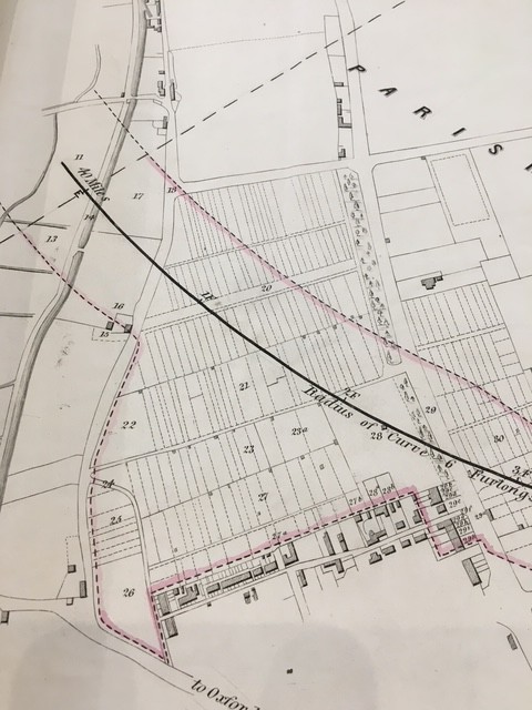
The plan to the No. 2 Bill showed the line running from the junction “six hundred and sixty yards north of the Wooden Bridge over the existing railways -ie the one leading from Aristotle Lane to Port Meadow- through to the south and east terminating “near the north end of the town of Oxford, in certain garden grounds” on the western side of Woodstock Road. So, (like the 1846 Bill) the line would pass just to the north of the houses in Plantation Road. The limits of deviation include the houses fronting Woodstock Road on the west side but exclude North Parade.

Again, the Deposited Plans and Book of Reference include detailed information about owners and occupiers of land within the Limits of Deviation.
The route through Walton Manor and North Oxford is the same in the two 1851 Bills, although the No 2 Bill stops at Woodstock Road, and follows closely the route proposed in 1846.
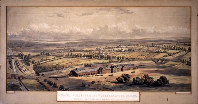
An artist’s impression of the proposed station shows the railway line and station crossing, and building upon, most of Walton Manor. With some artistic licence, this suggests how bucolic North Oxford was at this time. It does show the buildings then existing around North Parade, and The Shrubbery, and the corner of the wall around the Radcliffe Observatory but not the other Woodstock Road houses which would have been demolished if this scheme had gone ahead. The Plantation Road houses over which the Bill did not give compulsory purchase powers have mysteriously disappeared from this representation. It also shows in the background St Margaret’s Road, then called Rackham’s Lane.
The line would have crossed the canal by bridge, then the track north of Walton Well (the future Kingston Road) by level crossing, then continued by bridges under Woodstock Road and Banbury Road to the east of the station.
This proposal was vigorously opposed by, amongst others, the GWR, the Observer of the Radcliffe Observatory and several landowners affected by the proposed line, including St John’s College. The University also opposed it along with several other Colleges including All Souls, Brasenose, Christ Church, Magdalen and Merton. Some quotes from the Petitions of objection are included or paraphrased below.
On the other hand, the strong-willed Bishop of Oxford, Samuel Wilberforce, appears to have supported the Bill.
Most of the objections argued that a third railway line from Oxford to London was unnecessary, and that the OWW was not sufficiently well capitalised to implement the line if it was authorised.
The Bills were rejected by the House of Commons Committee delegated to consider them.
4. The London and Mid-Western Railways Bill (1852). (PD 2/60).
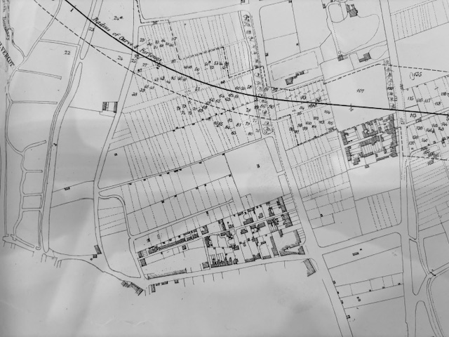
This proposed a new line from Wolvercot to Brentford and Willesden with a branch line to Aylesbury. This would have crossed the GWR lines and the canal further north than the OWW version but still south of the Aristotle Lane canal bridge, turning eastwards south of what is now St Margaret’s Road but north of what is now Leckford Road, and just along the northern edge of North Parade. Note that, as well as The Shrubbery, this plan shows the houses fronting Banbury Road built for John Parsons, a draper, in about 1840 called the Lawn (now 89 Banbury Road) and for GP Hester, the Town Clerk, in about 1835 called The Mount (demolished to make way for St Hugh’s College). [Plan 4.]
This Bill was a fairly blatant attempt to repeat the 1851 proposals under the name of the new London and Mid-Western Railway Company. It did not succeed.
All of these Parliamentary plans show in detail the layout and location of the houses within the Limits of Deviation, and to some extent those on either side. It is obvious that most of what is now Walton Manor was still subdivided into small agricultural, or market garden, plots, under the ownership of St John’s College and leased to the Duke of Marlborough, that is, the Blenheim Estate. Residential development within Walton Manor had, by then, proceeded no further north than Plantation Road.
Attached is a sketch showing the centre lines of the approximate routes of the 1846/1851 and 1852 proposals superimposed on a modern map of North Oxford. The 1846/1851 route is the one slightly further south. The incompatibility of either route with the development of North Oxford as a residential suburb is obvious.

Objections to the OW&W (No.3) Bill:
Petition by Mr Manuel John Johnson, FRS, who was the Radcliffe Observer from 1839 until his death in 1859, against the No.3 Bill expressed concern about noise and disturbance from the movement of trains, including goods trains at night, and particularly from traffic to and from the proposed station in Woodstock Road which would be only 360 yards away from the Observatory. He would refer in evidence to the “extreme sensibility of the mercurial reflector and instrument” so that vibrations would disturb the observations. Mr Johnson has his own Wikipedia entry.
According to the Petition by the Rev. W.W. Stoddart, one of the senior fellows of St John’s College, he would argue that the land to be intersected by the railway is “peculiarly adapted for building purposes and is the only land in the neighbourhood of the University which is adapted for that purpose. It is gravelly soil on rising ground intersected by wide good roads and the most pleasant situation for private residences in the neighbourhood of Oxford. The land is therefore of great value for erecting villas. There is a great demand for villa residences at Oxford…..It is in contemplation to build a new college at Oxford and part of the land affected has already been leased for that purpose. The superior value of the land referred to arises from its high situation, dry soil, ornamental character, easy access to the colleges in Oxford and to it being supplied with good walks and being removed from the general business of the City.” [As eloquent an argument for the creation of middle-class suburbia as one could imagine.]
The station proposed at Woodstock Road and the lines crossing Hutt Lane (on the level) and Woodstock Road and Banbury Road (by bridging) would “entirely destroy the value of the property render it unseasonable for the contemplated purposes of building superior residences and will be a lasting injury to the residents by the nuisance occasioned by the passing and repassing of trains”, made worse by the location of the station.
The affected roads-including the cross-roads- “are kept with great care in good condition and are the principal resort out of Oxford for the purpose of recreation and exercise by the inhabitants of both Town and University”.
By this time, of course, the College was contemplating the development of what would become North Oxford by terminating the Duke of Marlborough’s lease on the land west of Woodstock Road to the north of Plantation Road then used as market gardens when it expired in 1853, and developing designs for Walton Manor with Samuel Seckham, the designer of Park Town. Tanis Hinchcliffe’s “North Oxford” contains details of those designs, and of the College’s attempts to extract payment for its land from the railway companies if one or other was approved. The agreement with the London and Mid-Western Company, for example, provided for the College to sell 43 acres in total for £20,000.
The concept of connecting the railway to North Oxford was not quite dead; a suggestion was made in 1860 for a branch line and station for North Oxford just to the north of the University Parks, but this was no more than speculative.
Sources:
Oxfordshire History Centre (copies of Bills including Deposited Maps and Books of Reference, and the lithograph with the OWW Bill). The OHC has a useful list of “Plans, Sections and Books of Reference for the proposed Railways in Oxfordshire”. The PD numbers above are the reference numbers on that list.
National Archives (objections to the 1851 Bills).
Parliamentary Archives (all Bills and related proceedings including minutes of Parliamentary Committees- but note these will not be available during 2025 as they are in the process of being transferred from the Houses of Parliament into the National Archives at Kew).
Laurence Waters, “Railways of Oxford” (Pen & Sword Transport, 2020).
Bill Simpson, “A History of the Railways of Oxfordshire, Part 1: The North”(Lamplight Publications, 1997).
Bob Pixton, “Oxford, Worcester and Wolverhampton: Portrait of a Famous Route, Part One: Oxford to Worcester” (Runpast Publishing, 2003).
Tanis Hinchcliffe, “North Oxford” (Yale University Press, 1992).
Liz Woolley, “How the Railway changed Oxford” from Oxford Local History Association Journal 2013-14 pp 18-43.