STREETS ITEM
Adelaide and Observatory Streets
Originally part of the rural manor of Walton
As with the rest of Walton Manor, the area now comprising Adelaide Street and Observatory Street originally formed part of the rural manor of Walton, and was acquired by St John’s College in 1573 from the family of George Owen, Henry VIII’s physician.
The earliest known map of North Oxford, dated 1769, identifies this area as a “shooting glebe”, bounded on the south side by land let to the Duke of Marlborough with the “hospital ground” beyond, on the eastern side by the road to Woodstock and on the western side by an unnamed road which is now Walton Street. The map records the tenant of each plot, which is numbered.
This area is in two parts, the southern part of just over eight acres (Plot 11) and the northern part of over four acres (Plot 12) both let to a Mr Phillips, and separated by an unnamed road which became Horse and Jockey Lane (now St Bernard’s Road). Mr Phillips also held land from the College in other plots west of Walton Street, including the old Walton Manor Farmhouse, and further north. The land immediately to the south (Plot 10) and north (Plot 13) were both let to the Duke of Marlborough, who was tenant of several other parcels of land in what became North Oxford.
This map does not show any roads between Woodstock Road and Walton Street apart from Horse and Jockey Lane, or any buildings within this area, although the Horse and Jockey pub, a well-established coaching inn, and a building to the west of Walton Street which is probably the old Walton Manor Farmhouse, are shown nearby.
The rural area north of St Giles’ Church was generally known as St Giles’ Fields, with the land west of the Woodstock Road being called Walton Fields. There are references in some documents to part of this land being called “The Butts” which usually denotes a shooting or archery ground.
This map pre-dates the northward development from medieval Oxford, triggered by the construction of the Radcliffe Observatory and the Observer’s House from 1772-1778 (both now listed Grade 1 and part of Green Templeton College), the opening of the Radcliffe Infirmary in 1770, and the creation of Beaumont Street and St John Street in the early 1830s. Industrialisation followed, prompted by the opening of the Oxford Canal in the late 1780s, creating a need for housing for workers. That need increased with the move of the University Press to Walton Street in 1830, and the opening of Lucy’s Ironworks by the canal in 1826, and itself led to a tide of building work to construct the housing the workers needed.
In 1816, this area was still farmland; in that year the College granted a lease to Henry Hunt for 20 years from 10 October 1814 as a farm let, for a payment of £186 plus a rent of £6.13s,4d per annum. Henry Hunt was described as a “carrier” ie a transporter of goods, not a farmer so it is likely he was intending to let others do the farming. For reasons lost in time, this was described as a “moiety” ie a part share although this may just reflect the existence of historic manorial rights. He appears to have taken over the areas previously leased to Thomas Phillips, who is described as deceased, including the farm and farm house “which said Farm House was of late parcel of the Possessions Lands and Tenements of the late dissolved Monastery of Osney”.
The perception of this land as agricultural is emphasized by the commitments given by Hunt: as well as the rent he was obliged to provide to the College each year specified quantities of winnowed wheat and malt, 2 good fat capons, a contribution to the stipend of the Vicar of St Giles, 2 days “cartage” and a sum of money every 10 years towards an “entertainment” for the College when it held its court for the Manor of Walton. Almost medieval!
Plot 10 was transferred by the College, with the support of the Duke of Marlborough, to the Trustees of the Radcliffe Observatory in 1820, as authorised by a private Act of Parliament.
The College was beginning to see the need- and potential profit- for developing housing in North Oxford and perhaps to realise that if they didn’t control it others would make the profit out of doing so on their land. The area immediately north of the Observatory, on gravel above the flood plain, was the obvious place to start.
The College employed a surveyor called John Allan to carry out a preparatory survey and list of plots in 1827, and then applied for and obtained a Private Act of Parliament-the St Giles Enclosure Act- in 1829 so that it could fully control use and occupation of its North Oxford land. “Enclosure” generally refers to the process by which farmland previously cultivated in small sections under the so-called “open field” system- often for subsistence rather than for sale of the produce- was superseded by consolidation of the fields into larger and exclusive parcels, hence “enclosed”. This often led to a great increase in the efficiency of farm production. The “common rights” which locals had previously been entitled to exercise such as taking away timber or turf for fuel, extracting sand or gravel and allowing pigs and other animals to roam and feed were removed, and the commoners could not prevent development. Existing tenants were entitled to have their tenancy recorded properly, squatters were not.
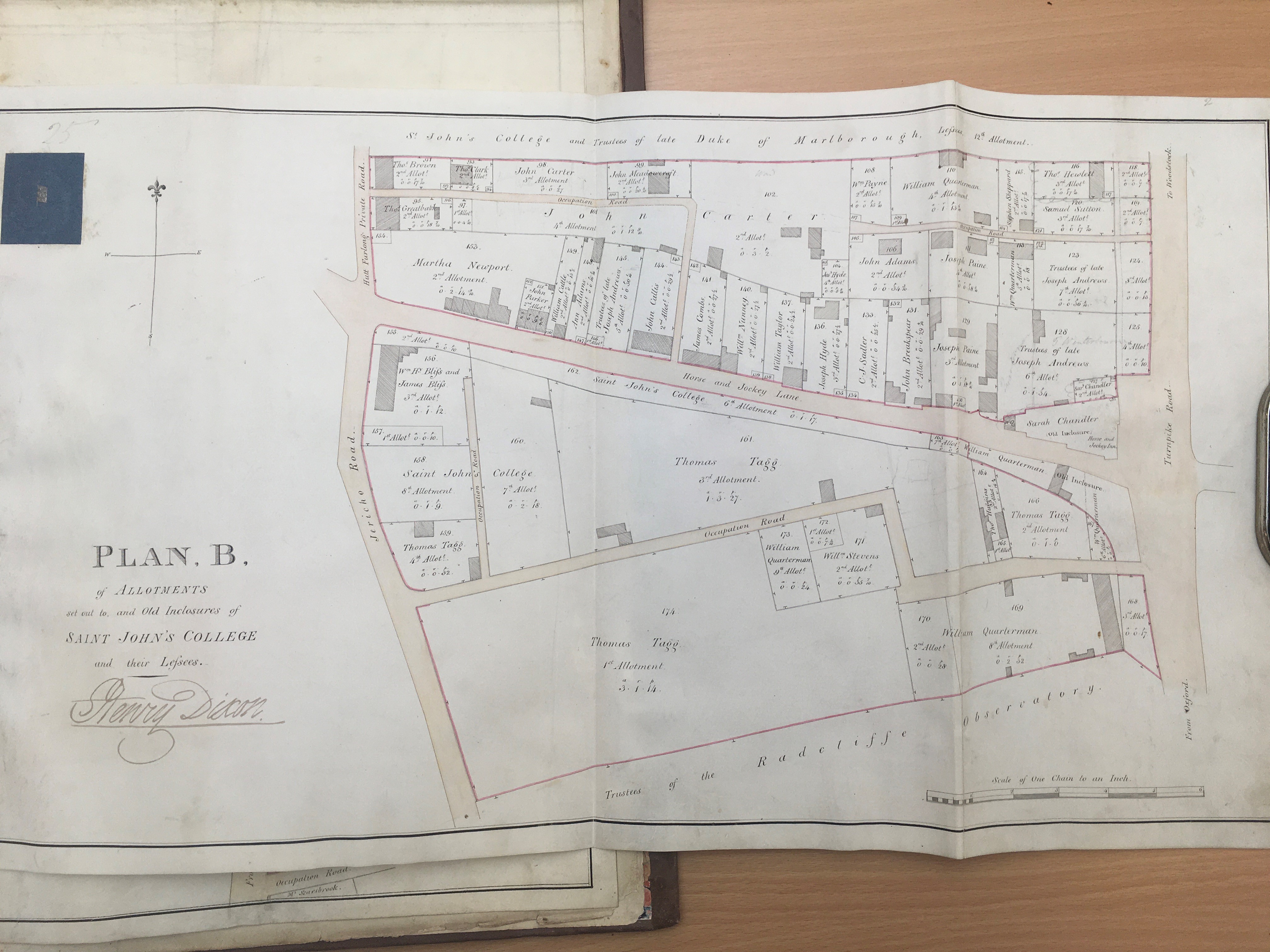
The detailed survey plans produced by Henry Dixon in 1832, which are attached to his Enclosure Award as the definitive record, hint at the future development of these two streets, and of Walton Manor more generally. The overall plan for the Parish of St Giles (Plan A) is supplemented by Plan B at a larger scale, which shows the area from the wall on the northern side of the Observatory site up to (roughly) the later Leckford Road (Fig. 1). The Award itself lists the names of the freeholder- St John’s College for all of this area-and of each tenant, and the area of their respective plots, and also describes the roadways both public and private.
At this date, Observatory Street had not been constructed, and Adelaide Street (described as “Occupation Road”) runs from Walton Street (here called Jericho Road) to Woodstock Road, with a dogleg emerging onto Woodstock Road. It is not one of the roadways described in the Award so was probably only a muddy track with no-one responsible for its upkeep. Few buildings had yet been built on the land south of Horse and Jockey Lane. These are likely to have been agricultural buildings such as sheds and greenhouses. One on the north side of Adelaide Street was described in Allen’s list as a “hovel, yard and washhouse”.
Other buildings recorded by Dixon nearby include the Horse and Jockey pub facing Woodstock Road, the Regency terrace which is now 45-55 Woodstock Road, the stucco terrace which is now 93-97 Woodstock Road (but not 91); several properties on the north side of Horse and Jockey Lane and a few in what is now Plantation Road (although the two ends of the roadway had not been linked then); “Walton Terrace” facing what is now the lower end of Kingston Road and 7 cottages facing Walton Street at the west end of Horse and Jockey Lane. Dixon did not record the land and farm house west of Walton Street either on Plan B or in the Award as this area was treated as already enclosed- it is marked on Plan A, with other land, as “Old Inclosure”.
As is apparent from Fig.1, most of the land on either side of Adelaide Street but south of Horse and Jockey Lane had been let by the College to Thomas Tagg who ran a substantial business as a nurseryman, seedsman and florist based at Paradise Gardens in central Oxford, with this area- known as Tagg’s Garden- and other land in and around Oxford being used to grow plants, trees, seeds and flowers for sale to Colleges and other landowners. A page from his Plant Catalogue of about 1820 is shown here (Fig 2).
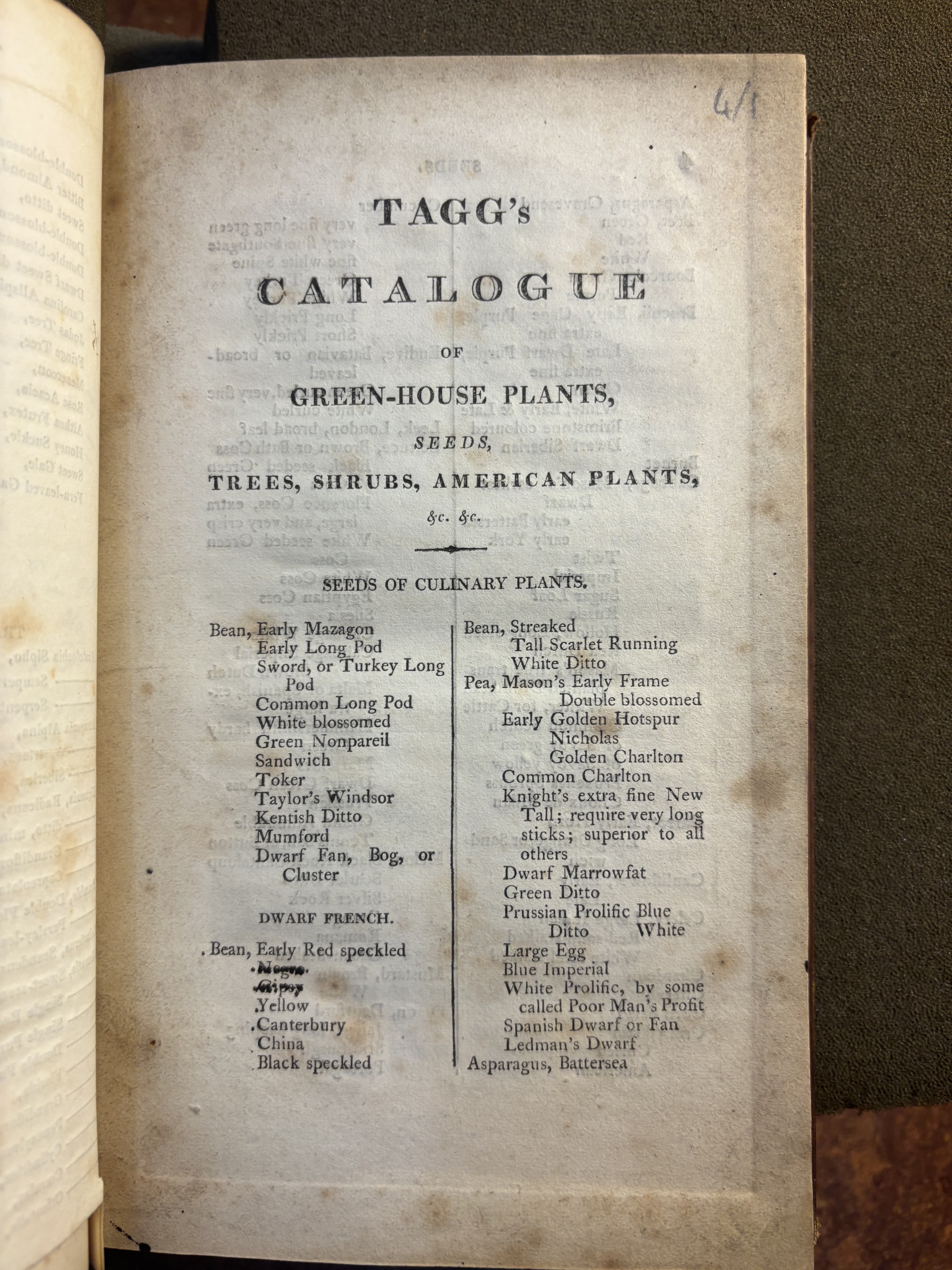
This business dated back to the early 1700’s when Thomas’ grandfather, also Thomas, married the widow of Jacob Wrench, whose family had established the business. Thomas junior inherited it from his uncle James.
Thomas originally took a sublease here from Henry Hunt. On 21 January 1824, Henry Hunt’s lease was surrendered and Thomas took a direct lease from St John’s College of 10 acres in total for 20 years from 10 October 1821. He was described as a “nurseryman”. The lease records that for “some years past” he had used the land as a nursery and garden. His lease obligations mirrored those in Hunt’s lease, reduced in quantum to reflect the fact he was only taking part of Hunt’s land. This did not include the land west of Walton Street containing the farmhouse or the land north of Horse and Jockey Lane. He had an additional obligation to “keep one able person to be resident and dwelling” on the land, who presumably lived in the hovel identified by John Allen.
The fragmentation of the former Walton Manor Farm is evident by 1824: most of the 4 acres north of Horse and Jockey Lane was let on the same date to John Carter, a bargemaster, with some smaller parts let to others.
The 1827 Allen plan suggests that Tagg had already subdivided his land into about 20 plots some of which were for letting. The same was happening on a more haphazard basis on the land to the north of Horse and Jockey Lane, where more small cottages had been built by 1827, probably without College approval.
The College was now actively seeking the development of this area for housing, and the first buildings were being erected with their approval. The earliest had been the terrace of 6 houses built before 1827 by William Quarterman (a breeches maker) facing Woodstock Road just north of the Observatory’s grounds, now numbered 45-55.
A series of leases, including one for 45-55 Woodstock Road to Mr Quarterman, one for the 7 cottages on Walton Street to Wm. Henry and James Bliss, one for a timber yard facing Walton Street to George Smith and one to Thomas and Benjamin Huggins, pipemakers, were granted on 5 October 1836 for terms of 20 years from 10 October 1835, to put into proper form the rights of the recognised tenants, free of the previous quasi-mediaeval obligations and of any “common” rights. A lease was also granted to a Mr John Hall of a house in Tagg’s Garden which Hall had recently built although it is not possible to identify which one with certainty. The going rate for a house was a lump sum of £20 plus a rent of 11s per year. Tagg was not one of the recipients of these leases; he died in 1836.
So far as can be established, no existing houses within Observatory Street or Adelaide Street pre-date the 1832 Enclosure Award, although most of them must have been built shortly afterwards.
The College’s progress in developing the area is obvious on the next available map (fig 3), dated 1843.
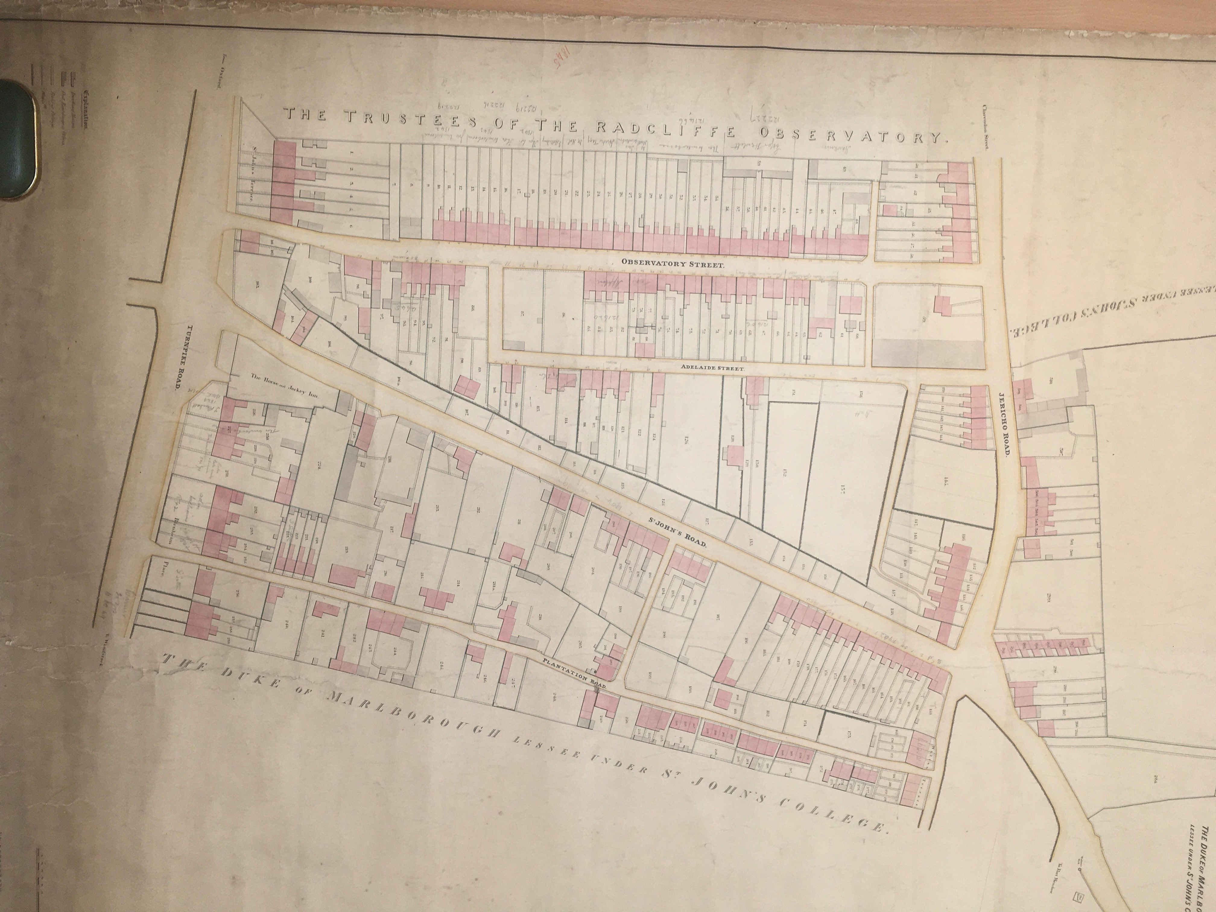
Observatory Street and Adelaide Street are laid out in the configuration they have today. Most of Observatory Street on both sides, and much of the north side of Adelaide Street, is shown divided into numbered building plots on which houses had been, or were being, built. College records suggest that, once the initial 1836 flurry of leases had been processed, a system was developed under which each plot was offered to a builder or investor on a 20 year lease (later, 99 years) to enable a house or houses to be constructed to a minimum letting value dictated by the College, with the lease being issued once the house was built.
This level of control was intended to make the houses of reasonable quality but also affordable both for the builder/developer/investors who would take the leases and for the class of working persons who would live there as occupying tenants (although those standards did not include sanitation-drainage was by open sewers to the canal until the Oxford Local Board installed proper sewers in 1875/6). Upstairs bathrooms were not installed in most houses until the 1960s. Unlike the later, grander, parts of North Oxford, these houses were not designed by architects or built by reference to a pattern book. Almost accidentally, the imposition of standard contractual terms achieved the consistency we see today in the frontages in Observatory Street and to a lesser extent in Adelaide Street.
The diaper brickwork frontages of the latter suggest a slightly earlier construction date than the predominantly stucco frontages in Observatory Street, although 45-47,50-53 and 56-65 on the north side of Observatory Street share the diaper brickwork facing, suggesting they were the earliest to be built in Observatory Street. 57 and 58 are three storey rather than two, illustrating how the conditions attached to sales of plots allowed builders some freedom to maximise their profit. The plot numbers shown on the map are for the College’s administration, not for postal addresses which were not fully in use by this date. It is likely that any horticultural use had ceased by 1843.
Certainly, the first nationwide census in 1841 shows that there were 12 households living in Adelaide Street and over 50 in Observatory Street by then. The census does not use house numbers but does give occupations, which include printer, compositor, builder, tailor, whitesmith, timber merchant and “yeoman beadle”, a very Oxford role then held by Thomas James.
The naming of Observatory Street and Adelaide Street on the 1843 map confirms that they had been constructed by then, probably with “hoggin”, a mix of clay and gravel from the gravel pits nearby. It is still noticeable that most of the houses open straight onto the street, and that the entrance step is slightly raised to keep street mud (or worse) out of the house.
The origin of the name Observatory Street is obvious, that of Adelaide Street less so. It is likely that it was so named in honour of Queen Adelaide, wife of King William IV who ruled from 26 June 1830 until his death on 20 June 1837, when he was succeeded by Queen Victoria. Specifically, the street name may commemorate Queen Adelaide’s visit to Oxford in October 1835. Apparently, she caused some fluttering of academic feathers at Christ Church by staying, and receiving the Mayor of Oxford and other visitors, at the Angel Hotel rather than at “the House” as was then usual for royalty.
Queen Adelaide survived her husband and died on 3 December 1849. The city of Adelaide in Australia-founded and designed for “colonists”, that is, free settlers rather than convicts- was also named for her in December 1836.
On this 1843 map Woodstock Road is still described as “Turnpike Road” and Walton Street as “Jericho Road” although in the 1841 census Woodstock Road is “St Giles’ Road” (later St Giles’ Road West to distinguish it from the lower part of Banbury Road which was called St Giles’ Road East) and Walton Street is “Walton Road”. Observatory Street and Adelaide Street both had their settled names by then.
The next map, by Hoggar in 1850 showing the whole of Oxford in great detail, shows some infilling to complete the terraces of houses on both sides of Observatory Street and on the north side of Adelaide Street, although there was still an undeveloped area towards the western end, roughly where Walton Manor Court is now. As on the 1843 map, the rear gardens of the Adelaide Street houses extend almost to St John’s Road. The large plot between the junctions of Observatory Street and Adelaide Street with “Jericho Road” is identified on the 1850 map as a timber yard.
Subsequent Ordnance Survey maps of 1876 and 1900 show little change in these streets apart from the construction of three pairs of semi-detached houses at the western end of Adelaide Street (by 1876) and the development of some houses along the south side of St John’s Road -as Horse and Jockey Lane was then called (by 1900). The areas beyond Walton Street to the west, Woodstock Road to the east and St Bernard’s Road to the north as far as Leckford Road were, however, now fully developed.
At the Walton Street end, Mr J. Davis, the timber merchant, built six shops with flats above in 1884/85, of local brick with slate roofs, now 106-111 Walton Street. These replaced what were described in the Oxford Journal as “dilapidated wooden shanties”. Number 106 was occupied for many years by Mr Alfred Maycock as a grocer’s shop. More recently it has been “Daisies”, florists, and is now a coffee shop, with the rear currently being re-developed for five apartments.
South of Observatory Street, the 1843 map shows a terrace of eight buildings, probably also shops or workshops with flats above. The present 112-118 Walton Street built by Walter Gray dates from around 1887, also brick with slate roofs, with some ornamental detailing on the upper part of the front façade. Walter Gray (later, Sir Walter) developed much of North Oxford in the late 19th century and became Mayor 4 times. His remarkable story-and that of his son Frank, MP for Oxford in 1922-24 until unseated after being accused of corrupt practices-is told in “The Other Oxford” by Charles Fenby.
A fictional description of life in Observatory Street in the late 19th century can be found in Pip Williams’ “The Dictionary of Lost Words” whose lead character, Esme, lives with her father in Observatory Street. Both participate in the assembly of the Oxford English Dictionary at James Murray’s “scriptorium” in Banbury Road.
Kelly’s Directory for 1924 gives a snapshot of the business activities in Observatory and Adelaide Streets- a much greater mix than we expect today, showing that “working from home” is not new. The house numbering follows the “up and back” rather than “odd and even” pattern adopted in the later 19th century.
In Adelaide Street:
12 John Chapman, plumber
13 Thomas R. Dodson, apartments (ie private lettings)
14 John Isaac White, boot maker
20 William Coates & Son, joiners.
In Observatory Street, south side, from Woodstock Road:
St Paul’s Vicarage, Rev. Roger Wodehouse M.A, Vicar of St Paul’s (now Freud)-this large house, numbered 1A, was built in 1905 and sold off in 1965 before St Paul’s Church itself closed in 1969.
1 Charles Bolton, house decorator
11 Miss Lilian Cox, dress maker
14 J&S Seary, photographers
19 Norman Arnold, grocer
21 John William Crapper, clothes clnr
30 Ernest Edwd Brown, cabinet maker
33 James Enser, paperhanger
34 William Francis, painter
38 John Fredk East, cab proprietor
39 Frank Smith, boot maker;
And on the north side
49 Edward John Talmadge, beer retlr
60 Percival Norris, shoe maker
65 Thomas Taylor hair dresser
Plume of Feathers P.H (80) Albert Thomas Searle.
This pub, and the houses alongside it, were demolished in the 1930s, along with the St Giles’ Brewery behind, to make way for Belsyre Court- see the entry for Woodstock Road. The Brewery and pub were run for many years by Daniel Hall; the Brewery was sold to the Northampton Brewery Company at the turn of the century. Daniel and several members of his family are buried in St Sepulchre’s Cemetery.
Not mentioned in this edition of Kelly’s is the Lord Napier pub at 48/49 Observatory Street which first opened in 1871 and was replaced by a larger building in 1930. It was one of many Halls Oxford Brewery pubs in and around Oxford although their distinctive “hare” tile no longer adorns the building. The monogram HOB for “Halls Oxford Brewery” is still on the side gate. The pub is believed to be named after Baron Robert Napier who led several colonial military operations in the 19th century and was appointed Commander-in-Chief of the British forces in India in 1870 (although the 1960s pub sign commemorated an earlier generation). The pub closed in the 1980s, became offices as Lord Napier House and is now accommodation for Green Templeton College, as are several houses on the south side of the street.
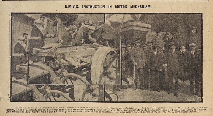
One other business in Adelaide Street is worth mentioning: Stevens & Co was a coal merchants with several branches across Oxford including by the railway at Rewley Road and by the canal at Frenchay Road. Fig 4 is a newspaper photo from 1918 showing mechanics being trained on maintenance of motor lorries at its Adelaide Street premises.
By 1938 it had become Stevco Ltd and its Adelaide Street premises were a “motor car garage”, with a branch for tyre distributors in Walton Well Road. Their Adelaide Street premises were where Walton Manor Court is now, as far as one can tell from the 1939 edition of the Ordnance Survey map.
The 20th century saw substantial development at the eastern end of Observatory Street and to a lesser extent in Adelaide Street. As mentioned, the construction of Belsyre Court and related offices and shops swept away the Plume of Feathers and the St Giles’ Brewery. The houses at that end of Observatory Street, on the north side, were replaced by a terrace of 1930s houses at 72-79 Observatory Street.
In Adelaide Street, Walton Manor Court, consisting of about 20 one-bedroom flats in several blocks, was built in the 1960s by St John’s College via a housing association with the rather twee name Homeville, replacing Stevco’s garage. Also, two cottages at 32 and 33 Adelaide Street, on the south side of the street, were demolished to allow for construction of four lock-up garages. The only cottages remaining on this side of the street, 34 and 35, illustrate just how tiny some of these early 19th century cottages were. 34 is currently (Spring 2026) on the market priced at £525,000.
Of the three existential threats to the existence of Walton Manor in its current form, the railway mania of the 1840s, the Council’s post-war obsession with getting traffic out of the city centre and the College’s desire to extract value from its North Oxford estate in the 1960s, Observatory Street was most at risk from the second.
In May 1945, the City Council commissioned Thomas Sharp to prepare a report on the planning and development of the city, published in 1948 as “Oxford Replanned”. This addressed the increasing congestion at Carfax where the north-south A34 then crossed the east-west Queen Street and High Street. Radical change was proposed. The report led to the completion of the ring road we all know and love, and Marston Ferry Road, but other proposals were more controversial, especially the so-called “Merton Mall” across Christ Church Meadows.
The report also suggested, as part of a “middle ring road”, a new road enabling traffic to get from North Oxford to the railway stations and to Botley Road and the western suburbs without going through the city centre. This would have run from the northwest corner of the University Parks, across Banbury Road and Woodstock Road, along the line of Observatory Street, across Walton Street and Jericho to a new Station Square. The loss of viable housing here was not mentioned although Sharp dismissed the housing to the north of the city centre as “slummy or outworn”. A footnote in the report suggests that, to avoid interference with Worcester College’s cricket ground, the link road would pass along the line of the canal which would have to be filled in. As we know, this part of the plan did not come to pass, although subsequent Council plans over the next 20 years did propose relief roads across Port Meadow and elsewhere.
What changed in the period of just over 25 years between the 1948 report and the designation of Walton Manor, including these two streets, as a Conservation Area in 1975?
Certainly, there was a country-wide cultural shift in the Zeitgeist from “old = bad” (so replace with “modern”) to “old = good” (so preserve). In Oxford, this was exemplified by the outcry over the proposed demolition of 56-64 Banbury Road and 1-11 Bradmore Road- examples of the Victorian Gothic which Sharp described as “gaunt and grim and ungracious” despite living in such a house himself- to be replaced by a new 90 feet high building for the Pitt-Rivers Museum, designed by the “master of concrete” Pier Luigi Nervi.
At a more domestic level, the proposal in the 1953 Oxford Development Plan to clear away the “slums” of Jericho (as was already under way in St Ebbe’s) provoked fierce and vocal opposition from the residents of Jericho represented by the Vicars of St Barnabas and St Paul’s, Councillor Olive Gibbs and others. This proposal was dropped from the final 1955 adopted Development Plan.
Other organisations such as the Oxford Civic Society, formed in 1969, professionalised the heritage lobby in Oxford. The Society advocated for innovative “Park and Ride” schemes to address the growth in commuter, shopping and tourist traffic into the City Centre and finally saw off the Council’s plans for inner relief roads. The Oxford Preservation Trust which had originally acquiesced to some of the Council’s destructive proposals across Oxford also played a part, living up to its name.
Under the surface, the Leasehold Reform Act 1967 gave long-term tenants of houses the right to buy their freeholds. This loosened St John’s grip on its North Oxford estate, encouraged widespread emotional as well as financial investment in individuals’ houses and “raised the ante” for any Council contemplating a Compulsory Purchase Order to demolish housing. The Act also had the consequence that the extraordinary inflation in property prices from, say, 1973, onwards benefitted the house owners who had “enfranchised” rather than the previous landowners and landlords such as St John’s College.
In Walton Manor, the formation of the Walton Manor Residents Association in 1973 - based at 29 Observatory Street which the College kindly made available as a social hub for about 10 years- directly influenced the designation of the area as a Conservation Area in April 1975 equivalent to, but distinct from, the North Oxford Victorian Suburb first designated in 1967. Jericho was likewise designated as a Conservation Area in 2011.
Over the 50+ years since 1975, the character of the Walton Manor area, with its small terraced houses and narrow street pattern, has largely been preserved. In particular, the attractive multi-coloured sweep of the late Georgian terraced houses on the south side of Observatory Street is one of the key vistas defining that character.
Figure 1 and 3 maps reproduced by permission of the President and Fellows of St John’s College, Oxford. 1832 map ref: EST III.MP. 43(b). 1843 map ref: EST.III.MP.52.
Figure 2 Tagg catalogue reproduced by permission of the Provost and Fellows of Worcester College, Oxford. Library ref XZA.2.19(4).
Figure 4 with thanks to Oxfordshire History Centre.
And generally, thank you to the Archivists at St John’s College, Oxford for access to their records including the 1769, 1827 Allen and 1832 Dixon maps, lists and Award and their lease ledgers: 1811-1821: I.A.I0 and 1821-1829: I.A.II.
Posted - March 28, 2026