STREETS ITEM
Walton Street
Linking Jericho to St Margarets
Walton Street forms the western boundary of the Walton Manor Residents Association “patch”.
The Walton Manor Residents Association area starts at the perimeter wall of the Radcliffe Observatory Quarter (which was probably erected when Observatory Street was laid out in the 1830s) and runs up Walton Street to the Victoria PH at the corner of St Bernard’s Road, as well as east to Woodstock Road. It encompasses nos.90 (the Victoria) to 118 Walton Street (the Mind charity shop next to the Jericho Health Centre). Because the numbering in Walton Street follows the archaic “up and back” system, the numbers on the eastern side run consecutively north to south rather than the usual “odd and even”.
Only the eastern side is included, and that also falls within the Walton Manor Conservation Area. The western side of Walton Street falls within the Jericho Conservation Area.
“Walton Manor” and Jericho are of course closely linked in many ways, through history, architecture and demography and Walton Street forms a principal access route to both. It is named after the manor of Walton, a small hamlet then outside the city of Oxford. Although early maps and records are not precise, it is thought the original “Walton Manor Farmhouse” was in roughly the location of the cemetery of St Sepulchre’s.
At the southern end of Walton Street, the earliest known building was Beaumont Palace, also known as the King’s Houses, built in about 1130 by Henry I, outside the walls of Oxford but convenient for his royal hunting-lodge at Woodstock. This was the birthplace of his grandsons Richard (the Lionheart) in 1157 and John in 1166. For their father Henry II it may also have been conveniently close to his mistress Rosamund Clifford .
Edward I was the last king to use Beaumont as a royal palace. Edward II later allocated it to the Carmelites (the White Friars) in 1318.
Most of the buildings were dismantled following the Dissolution of the Monasteries and the building stone re-used in the construction of Christ Church and St John’s. Some romantically derelict sections remained. The Palace is commemorated by a plaque on the corner of Beaumont Street.
On the opposite corner, where Worcester College now stands, was a Benedictine “studium” called Gloucester College, founded in 1283. This place of learning was dissolved in about 1539 along with the monasteries, although the medieval “cottages” on the south side of the main quad have survived. The buildings passed to the Bishop of Oxford and were then acquired in 1560 by Sir Thomas White, founder of St John’s College, and became Gloucester Hall.
In 1714 the Hall was re-founded as Worcester College and new buildings were developed over the next sixty years, the last to be completed being the Provost’s Lodgings in 1776.
The context for Walton Street changed with the establishment of the Radcliffe Infirmary in 1759, the development of the Radcliffe Observatory from 1772 and the opening of the Oxford Canal in 1790. The name “Walton Street” seems to have been first used in 1772; previously this little used track was called “Jericho Street” or “Jericho Road”.
In order to expand the City and improve access to Worcester College from St Giles, Beaumont Street was laid out in the 1820s, enabling St John’s, who owned the land, to profit from the development of housing there and in St John’s Street. The last remains of Beaumont Palace were probably “recycled” at this time. William Turner “of Oxford” who lived at 16 St John Street from 1833, recorded the building work in watercolours some of which are in the Ashmolean.
The opening of this new route to the north-west of the City stimulated the northward development of housing along Walton Street. Further commercial impetus was encouraged by the establishment of the Eagle Ironworks next to the canal near Walton Well in 1825, and the move of the University Press to Walton Street in 1826. St John’s authorised the development of their field east of Walton Street, previously known as Walton Close, in 1824 although building took place piecemeal and it was not until the 1840s that this area was fully let. St Paul’s Church (now Freud), in Greek Revival style, opened in 1836 to serve the growing population.
St John’s gradually increased their grip on the next area, to the north of the Radcliffe Observatory, first by commissioning a survey in 1827 and then by seeking an Enclosure Bill which was achieved in 1829. This enabled the College to start to plan, and control, the development of housing on their land. The Enclosure Map dated 1832 shows that at this stage Adelaide Road had been formed, although not named: there were no buildings on the Walton Street frontage south of this, which formed part of “Tagg’s Garden”; on the north corner of this “occupation road” was a small building allocated to Mr Tagg, with another open space allocated to St John’s adjacent, then a building allocated to William and James Blys on the site of the Victoria. At this date, Walton Street was named as Jericho Road and St Bernard’s Road as Horse and Jockey Lane. Observatory Street did not exist, in either form or name, except as a short link from the end of Adelaide Street to Woodstock Road.
By the time of Hoggar’s map of 1850, Observatory Street and Adelaide Street had been laid out, and named, in their current locations and Horse and Jockey Lane had been re-named St John’s Lane. The eastern side of Walton Street now included a terrace of about 8 buildings between the Radcliffe perimeter wall and Observatory Street, a timber yard between Observatory and Adelaide Streets, a row of 12 cottages north of Adelaide Street and, after a gap, another group of houses up to St John’s Road.
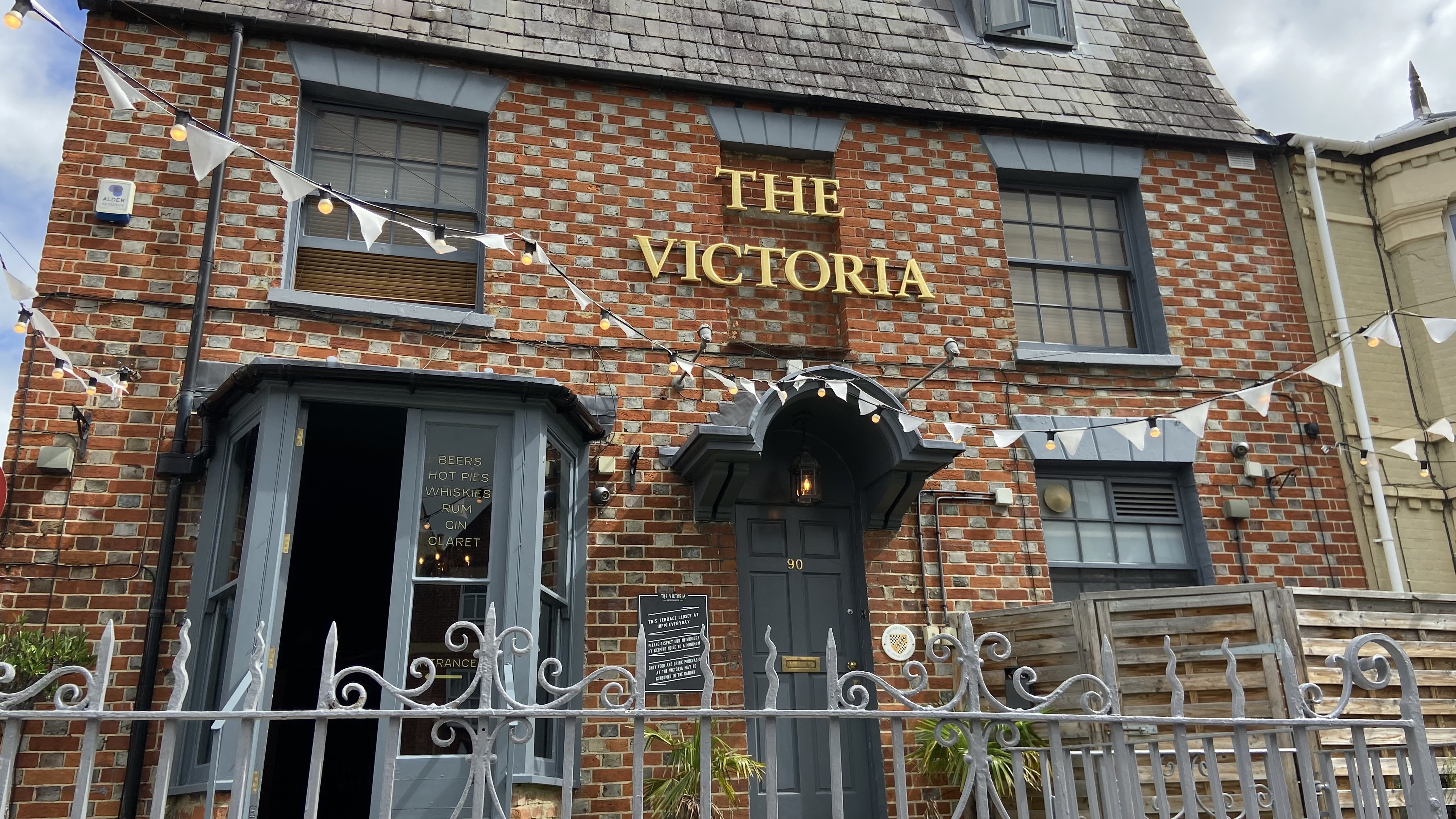
Following the Beerhouse Act 1830, pubs and beerhouses were required to be licensed by the local magistrates. The Victoria is a good example of the consequences: the lease of the site (described as “The Victoria” with washhouse or brewhouse) was acquired in 1839 by Charles Tawney from William Henry Bliss and James Bliss, described as painters. Charles Tawney was joint owner of the Swan Brewery in St Thomas’s (Hall & Tawney, later Hall’s Brewery). He had been Lord Mayor of Oxford in 1837/8 and was again in 1840/1.
Development had also rapidly expanded in Jericho with the formation of Great Clarendon Street, Wellington Street, Union Street (now Hart Street), Cardigan Street and Jericho Street although construction had not reached as far north as Juxon Street or as far west as the canal. St Sepulchre’s had been allocated as a burial ground.
The 1876 Ordnance Survey map shows little change in Walton Street, although more housing had been completed in the streets on either side, and the timber yard was still in place.
According to their annual report in Jackson’s Oxford Journal of 11 October 1884, the Oxford Local Board had in the previous year enabled the construction of 6 houses to be used as shops between Observatory and Adelaide Streets on the site of the timber yard (now nos.106-111) as well as carrying out improvements to the roadway of Walton Street.
The 1900 Ordnance Survey map shows the site between Observatory and Adelaide Streets now terraced, and a Wesleyan Methodist Chapel in the gap between nos. 91-94 and nos. 96-101.
The 1921 Ordnance Survey map shows more distinctly a terrace of 7 buildings between the Radcliffe perimeter wall and Observatory Street, a terrace of 6 buildings between Observatory and Adelaide Streets, a row of 4 shops (and a tiny unit) north of Adelaide Street, a terrace of 6 houses up to the Chapel, another terrace of 4 houses north of the Chapel, and the Victoria on the corner.
There has been little structural change since then apart from the replacement of the Methodist Chapel by the construction of Kingston Court, a 1960s block of flats with parking below. The terrace of houses at nos.96-101 Walton Street has been listed Grade II, citing its typical diaper brickwork on the front elevation. The listing suggests a lease date of 1829, although these buildings are not shown on the 1832 Enclosure Award. The later group of 4 houses beyond Kingston Court is not listed, nor is the Victoria.
Although there has been little physical change, there have been many changes in the uses of the shop units. Working from north to south, here is a comparison of the uses today, and those shown in the 1924 edition of Kelly’s Directory:
NUMBER |
TODAY |
1924 |
101a |
101 Coffee |
William Durham, greengrocer |
102 |
Mamma Mia Pizzeria |
William Hurrell, furniture |
103 |
Lynrace Spirits and Cocktail Bar |
Ernest Howes, basket maker |
104 |
Walton Street Wellness |
Ernest Money, hairdresser |
105 |
Manos Fresh Food |
Ernest Bowen, glove maker |
(Adelaide Street) |
||
106 |
Daisies Flowers |
Alfred Maycock, grocer |
107/108 |
Jamal’s Indian Takeout |
F.C.Bayliss, cycle agents |
109 |
Branca Deli |
William Warwick, fried fish |
110/111 |
Branca Bar and restaurant |
Thomas Johnson & Son, house furnishers |
(Observatory Street) |
||
112/112a |
The Jericho Café |
Thomas King, tailor |
113 |
JCP Estate Agents |
Ernest Alden & Sons, butcher |
114 |
Koto |
A. James & Sons, bakers |
115 |
Crawford & Co |
Miss H. Knight, confectioner |
116 |
Jericho Pharmacy |
Thomas Burbank, chemist |
117 |
The Standard |
Mrs MM Walker, greengrocer |
118 |
Oxfordshire Mind |
Hughes & Sons, cabinet makers |
With the development of Jericho and Walton Manor west and north
of Walton Street and then the further expansion of North Oxford
and the opening of bridges to Port Meadow, Walton Street became a
more significant north-south route in the later 19th century.
In response to the demand for access to the city centre and railway
station from all this new housing, the City of Oxford and District
Tramway Company was established to create and operate a horse-
drawn passenger tramway system, which came into service from
1881. One of the routes ran up Walton Street to the junction with
Kingston Road, and later to St Margaret’s Road. Proposals to replace
the horse-drawn trams, which ran on rails, with an electrified system
were authorised by Parliament in 1907 but did not proceed due to
opposition from the University and some Council members.
The horse tram service ceased in 1914 and was replaced by motor
buses following commercial competition known at
the time as the “bus wars”. Following privatisation of the bus
system in the 1980s (and more “bus wars)”, there are now no buses
serving Walton Street.
Due to the popularity of Walton Street for pedestrians, parking is
controlled and a 20mph limit applies, with traffic calming measures
in place. Recent proposals to create a traffic-free central section have
not proceeded but have not been forgotten.
Posted - January 18, 2024