STREETS ITEM
Kingston Road

Walton St becomes Kingston Road in Walton Manor
Kingston Road, like several other roads in North Oxford, is named after one of the parishes for which St John’s College held the advowson, the right to nominate a candidate for vicar, in the latter part of the 19th century. It was named for Kingston Bagpuize, west of Oxford.
Little is known of the mediaeval or pre-mediaeval history of this area north of Walton Well. The only known archaeological find is the coffined grave of a young woman aged 25-30 and a child at 16 Kingston Road during construction work in 2005; probably dating to the 4th century. Roman pottery was also found. Previous excavations in Kingston Road in 1883 produced a small iron dagger.
Long before the arrival of the canal and the railways, there was a track leading north from Walton Street. This is believed to be the route by which King Charles I and his son Charles (later Charles II) escaped from the (first) siege of Oxford by the Parliamentarians on 3 June 1644, joining up with their troops on Port Meadow and regrouping with other Royalist troops westwards through Wolvercote and Burford towards Worcester.
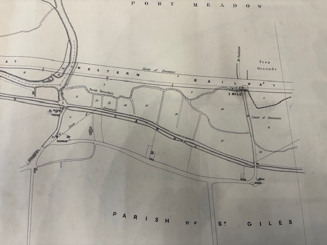
The oldest known map showing this area in any detail, a map of the Parish of St Giles surveyed in December 1769 - pre-dating the Oxford Canal, the Observatory, the first John Radcliffe Hospital and the Railways - shows “The Old Road” more or less along the line of Kingston Road today, as well as the names of the numerous lessees or occupiers of the land on either side and the area of their respective holdings. The original map is in St John’s College’s archives.
The track led from the northern end of Walton Street (sometimes then known as Jericho Road) at the junction of the roads which were then Walton Ford and Horse and Jockey Lane, now called Walton Well Road and St Bernard’s Road, northwards towards the pub known as “The Hutt” and the track leading on to Port Meadow, where Aristotle Lane is now. Walton Ford led through Castle Mill Stream to Port Meadow and on to Medley, Binsey and Wytham.
St John’s Enclosure Award map of 1832 shows little change apart from the arrival of the canal, with a bridge leading to the ford. The track north to the Hutt was then described as “Hutt Furlong Private Road”.
The Enclosure Award started the slow process by which St John’s recovered control of its land in North Oxford and started to contemplate development for housing, working first from the eastward side of Banbury Road and northwards from Observatory Street.
However, by the time of Robert Syer Hoggar’s elaborate and detailed map of Oxford in 1850, which showed Jericho, Observatory Street, Adelaide Street, St Jon’s Road and Plantation Road at a house by house level, the area north of Walton Ford was still “off the map”.
Kingston Road was laid out in the 1870s by the Oxford Local Board (the predecessor of the City Council) at the cost of the College to enable their development of housing along Kingston Road and the adjacent streets. The track, and the north end of Walton Street, could be re-aligned once the gravel mound known as Cabbage Hill at the western end of Plantation Road was removed for use as ballast on the construction of the Buckinghamshire Railway Company’s line from Oxford to Bletchley, around 1850. The original line of the track up to the Hutt is shown on the 1846 map below.
This map is oriented east/west and shows the Oxford Canal with the line of the Great Western Railway- authorised but not built by then- beyond.
As is apparent, there were very few buildings along the track then, or on either side; development came later. The shop at the junction of Horse and Jockey Lane, now St Bernard’s Road, is probably the original part of 179 Kingston Road which dates to 1835-1840. The building part way along the track was a cart shed and yard occupied by a Mr John Clark, a tenant of St John’s, who farmed the adjacent pasture fields down to and beyond the canal. The Hutt is visible at the Aristotle Lane corner.
Also shown on the map, although not very obvious, is a bridge crossing the canal about where no.3 Southmoor Road is now. This was canal bridge no.239 (no.240 is the Aristotle Lane bridge and no.242 is the Walton Well Road bridge). This was a wooden lifting bridge known, for reasons that are not entirely clear, as the Workhouse Bridge. It may have been the route by which working parties were brought from the Workhouse, then in what is now Wellington Square, to work on the land beyond the canal or into Port Meadow.
By 1851, two terraces of housing had been built either side of the western end of Plantation Road, the southern one of which, built in the diaper patterned brickwork typical of the time and then known as Walton Terrace, remains as 175-178 Kingston Road. The other, known as Kingston Terrace, was replaced by 1870.
This photo of the northern end of Kingston Road in 1872 shows how rural this part of Oxford still was, just before development reached here.
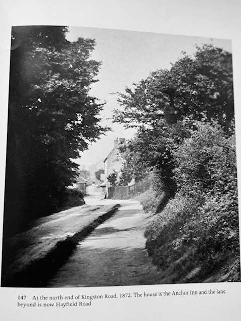
The foundation stone for St Margaret’s Church, built to the right of the location of this photograph, was laid in 1883. The Church was consecrated in 1893.
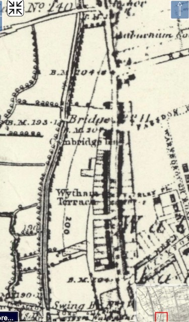
Below is an extract from the OS map, published in 1887 but surveyed in 1876, showing the same length of Kingston Road-now named- from “Walton Ford” to the Anchor pub, Heyfield Hut Wharf and Aristotle Lane. This map is oriented north/south.
As this suggests, the bridge over the railway at Walton Well was a swing bridge. It was replaced in about 1882 by the present “girder” bridge, at the behest of the Oxford Local Board.
Houses had by then been built along Kingston Road most of the way up to St Margaret’s Road (then called Rackham’s Lane). Wytham and Cambridge Terraces are named. Some houses are shown in Leckford and Warnborough Roads, but those roads were not completely developed. Farndon Road (named Farndon Place here) had been laid out but the houses not built at this date, and Southmoor Road had not been started. The “Workhouse Bridge” over the canal is still shown.
The contrast between the rural emptiness of the 1846 map and the busy development of the 1876 map is very obvious.
Walton Manor Residents Association’s area runs north from the Walton Well Road/St Bernard’s Road junction up to the junction with Southmoor Road on the west (so numbers 1 to 62) and Farndon Road on the east (so numbers 114-179). All except numbers 165-179 are within the North Oxford Victorian Suburb Conservation Area. 165-179 are within the Walton Manor Conservation Area. Unlike other local streets, Kingston Road does not appear to have undergone re-numbering, although it follows the anachronistic sequential system of numbering up one side and down the other.
The section of Kingston Road from Walton Street up to Southmoor Road/Farndon Road was developed in a series of groups, broadly from south to north, over the period 1865 to 1883, with the eastern side being built a little earlier than the western side. The College clearly intended Kingston Road for “artisans”, ie lower middle class workers, distinguishing this area from the genteel villas east of Banbury Road in the level of spend per house they required, and the level of ground rent they imposed in the leases- but also maintaining a standard higher than the lower working-class Jericho just to the south, nearer the canal, and less well provided with sanitation. As we will see, this desire for control of class or moral standards included a ban on public houses within their estate. Conversely, the College supported the provision of churches and schools as the population grew.
According to the gazetteer in Tanis Hinchcliffe’s “North Oxford”, which does not cover 1-13 or 165-179, the earliest lease granted on the eastern side of Kingston Road was of 157 and 158 in 1868 to Thos Harris, a publican, and the earliest lease granted on the western side was of no 23 in 1872, to Mary Ann Leach, a spinster. This house and nos 20-22 and 24-27 were all built by John Horne, who took the lease of no 27 himself. Other builders were Samuel Hutchins at 14-17 (he took no 17 himself), Brucker at 18 and 19, Holt at 28-40, John Money at 47-52 (he took all 6 leases himself, no doubt to rent out), Crapper at 53-60, Walter at 129-138 and 159-174.
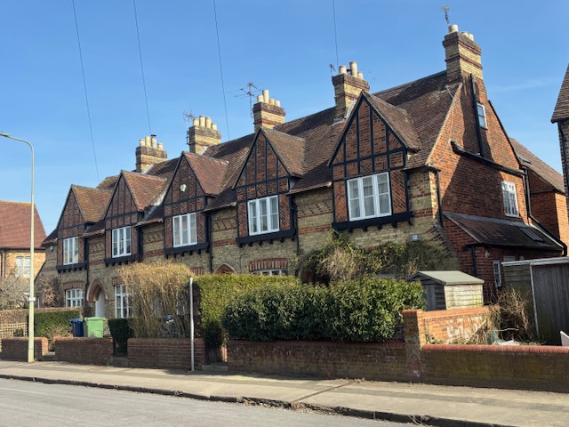
Some were designed or built under the supervision of architects-Geo. Shirley in the case of 41-46 and C.C. Rolfe in the case of 114-138 and 149-156 and 159-164. The Rolfe-designed terraces are all listed Grade II. 114-138 and 149-156 are described as “artisan terraced houses by Clapton Rolfe in the polychrome style of Butterfield (illustrated on page 165 of “First and Last Loves” by John Betjeman). 1 storey plus attic houses of polychromatic brickwork with gabled dormers and bay windows. Pairs of arched entrances divided by a column. Good detail. Interesting example of influence of Butterfield in Oxford. Tiled roof, brick stacks.”
159-164 are described as “Clapton Rolfe. Polychrome brick. 1 storey and attic with bay windows and arched paired entrances with central column. Tiled roofs with gabled dormers and brick stacks. No 164 is a slightly larger corner house.”
164, also known as Well House, is oriented towards Leckford Road rather than Kingston Road, and has been altered since its construction. Its south-facing aspect is now painted white.
Butterfield refers to William Butterfield, best known for Keble College, completed in 1870. Wilkinson and Moore, the most “North Oxford” of all architects, were involved in no 81 upwards.
Occupations of the first leaseholders ranged from “Gentleman” to “Grocer”, “Boat Builder”, “Photographer”-Robert Hills, who had a big house on Woodstock Road- to “Engine Driver”. No doubt Hills and others bought the leases to act as landlords; others bought the leases as owner-occupiers.
A more meaningful analysis of the occupiers and character of Kingston Road 100 years ago can be gleaned from Kelly’s Directory for 1924. Not every road number is covered but it is clear there were numerous retail businesses there, and quite a few boarding houses (whether for University students or commercial people is not always clear).
Retail units included:
George Howes, confectioner, at no 1
Miss Jane Warren, bookseller and sub-post office, at no 5
Symes and C, coal merchants (presumably an office) also at no 5
Fred Huggins & Son, butchers, at no 6a
Walter Thorne, beer retailer, at no 13
William Lewis, butcher, at no 14. This later became a greengrocers, and has been operating as Kingston Fruiterers, a wholesale business for many years.
G.T. Jones & Co Ltd, wine merchants, at no. 15
John G. Blencowe, grocer, at no 20 (his family previously had a bakery in Plantation Road)
Arthur Nutt, boot repairer, at no 24
Stevens & Co, coal merchants, at no 57
The Oxford Window Cleaning and Carpet Beating Company at no.61
W. Coates & Son, joiners, at no 123
Henry Coles’ Medical Dispensary and Lying-in Charity, at no 127
Miss Jessie Coles, grocer, at no 128
George Rainsley, watch maker, at no 135
S.W. French & Son, carpenters, at no 144. This business later became a firm of funeral directors under the same name.
A. White & Co, confectioners, at no 165. This later became J.P. Kennedy, butchers.
Edwin Smith & Co, ironmongers, at no 179.
There were apartments or boarding houses at nos 15, 16, 18, 19, 25, 30, 31, 33, 42 and 140.
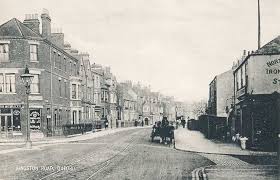
A general view of Kingston Road is shown on this postcard from 1905, showing the confectioners at no 1 on the left and the ironmongers at 179 to the right. This shop lasted many decades, later becoming a locksmiths and then, as many will remember, a party shop under the name of Partymania then Frog Orange. It is now derelict and sealed by hoardings as the original buildings are unsafe. St John’s College, who still own it, have planning permission to demolish the current buildings and erect a block of 5 apartments.
This postcard also shows the tracks of the horse drawn tram line which was installed by The City of Oxford and District Tramway Company in 1884 to connect Walton Street and Kingston Road to the City Centre. The horse tram service was discontinued in 1914 due to competition from motor buses.
Sadly, the tram line was not good news for all: a Mr Frederick Sammons of Plantation Road, aged 74 and very deaf, lost his life on 1 May 1886 after being hit by a twin-horse drawn tram while crossing Kingston Road to have a picnic lunch with his granddaughter on Port Meadow (as reported in Jackson’s Oxford Journal for 8 May 1886).
On a happier note, another report from Jackson’s Oxford Journal provides an insight into the life of the citizens of Kingston Road. This comes from the edition of 2 September 1882, reporting on the proceedings of the City’s Licensing Justices. The issue was an application by a Mr Walker for the grant of an off licence (then called an outdoor beer licence) for his new building in Kingston Road, now no 13, the Grog Shop. This followed on from a hotly debated application for a full public house licence at 47 Great Clarendon Street which had incurred the wrath of the Executive Council of the Church of England Temperance Society of the Diocese of Oxford, represented by Sir William Herschel, the Committee of the Oxford Band of Hope and Temperance represented by the Rev. F.J. Chavasse (rector of St Peter-le-Bailey) and St Barnabas represented by the Rev. E.V. Collins. That application was refused with the cutting words that there was “not the least ground for the application.” Another application for a full licence at 7 Botley Road was likewise refused.
A previous application for 13 Kingston Road had been refused and some of the immediate neighbours objected again, partly on the basis that the value or letting value of their properties would be reduced. Evidence showed that there were several licensed premises to the south, in Walton Street and the side streets but the nearest to the north was “Heyfields Hut” at Aristotle Lane, and that there was a lot of housing recently completed or under construction nearby (in Walton Well Road and Southmoor Road, for example). It was known that St John’s College would not allow public houses on their estate. A petition in support of the application had been signed by 121 people. The chair, Mr Galpin, made the key point in questioning the lead objector, Mr Slattery: “ If you were sending out a child of yours, say a little girl 12 years of age, to fetch some beer for your dinner or supper, would you prefer sending her to a house where men were drinking, and perhaps swearing and smoking and spitting about the place, or to a respectable house where there was nothing of the kind?” After a rather equivocal statement from the Rev. E.C. Dermer, Vicar of St Philip and James -who said he was not a very zealous partisan of the temperance cause- the application was granted.
The 1883 “Drink Map of Oxford” produced by the Committee of the Oxfordshire Band of Hope and Temperance Union shows premises licensed to sell alcohol with variously shaped red dots; there is an obvious contrast between the chicken-pox of Jericho and the few freckles north of Leckford Road.
A later glimpse of life in Kingston Road is given in “Oxford Boy” by Will Wyatt (subtitled “A Post-War Townie Childhood”): Will was born in 1942 and brought up at 15 Kingston Road, above the wine merchants G.T. Jones, which his mother managed. His memories of his time at “Phil and Jim’s” primary school are particularly vivid. Will later became a BBC producer and eventually Managing Director of Television there.
Bringing the past up to date, this photo shows the exterior of no 20, with Mr Blencowe’s shopfront still fresh, and the ghost of Hovis advertising on the side of the building.
The advertisement reads:
“J.G BLENCOWE/CORN FACTOR/PASTRY COOK/ GROCER/AND/CONFECTIONER
Champion Prize and Silver Medallist 1926”.
Mr John George Blencowe (son of John Blencowe who set up and ran the previous bakery in Plantation Road) opened the shop around 1879. It later became a post office as well. He died in 1892 and is buried in St Sepulchre’s Cemetery. His widow Emma carried on the business until around 1911 when their son Walter took over; he sadly committed suicide there in 1924. His sister Lucy and her husband then appear to have taken over the business. Mrs Emma Blencowe died in 1938, 46 years after her husband. The business was still listed in Kelly’s Directory as Blencowe and Co., grocers and post office, until 1966, and continued until at least 1973 under the name B.A. Brant & Sons, Ltd.
After a succession of planning applications between 2001 and 2015 no.20 is now a house with a second house at the rear. The bakery itself was demolished in around 2005. One of the planning conditions required the advertisement to be preserved. The family tradition has been continued by Jordan Blencowe and his wife at Blencowe’s Afternoon Tea Lounge in Banbury, near Banbury Cross.
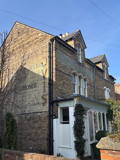
There is a shopfront similar to no.20, but smaller, at no 128-Miss Coles’ grocery- and a ghost advertisement for “Oxford…” just about visible on the side of no.114.
The buildings in Kingston Road show, externally, little change over the 150 years since they were constructed. Two significant but more subtle changes have taken place: firstly the ebbing of the tide of commercial uses -the only remaining active shopfront apart from the Grog Shop is the new coffee shop Broche at 165 Kingston Road on the corner of Leckford Road, and the boarding houses have been superseded by Houses in Multiple Occupation-and secondly the change of ownership following the Leasehold Reform Act 1967 which gave leaseholders the right to buy the freeholds of their houses from St John’s. As a consequence of both these factors, many houses have been improved by their owners by the addition of rear extensions to create larger kitchens/dining areas. Some have been designed more in keeping with their “parent” houses and neighbours than others. With the withdrawal of St John’s paternalistic control through leases, inconsistency has crept into the appearance of facades and front gardens, including an array of bin and cycle stores. However, Kingston Road is largely free from the visual blight of cars on driveways, and, because the houses are terraced and smaller, has avoided the blocks of flats which have gifted Woodstock Road a rather clumsy mix of architectural styles.
The North Oxford Victorian Suburb Conservation Area Appraisal from 2017 covers a much wider area than Kingston Road but does identify the Kingston Road area as one of its “Character Areas”. Positive features of that area include Landscape- particularly trees and shrubs in front gardens- and Ambience- generally light and open. Negative features include the lack of consistency mentioned above eg mismatched skylights; visual impact of wheelie bins and bicycle storage; traffic in term-time; dense on-street parking; poorly maintained road surfaces and pavements; unsympathetic street lighting. The Appraisal did not include any plan to rectify any of these negative features.
The Appraisal also identified a number of buildings within the Conservation Area which are not listed but are “deserving of further consideration either nationally or locally to avoid degradation or loss to buildings of architectural and historic interest”. In Kingston Road, the Appraisal specifies the following:
22-27 consec.
35-40 consec.
106-111 consec.
47-53 consec.
Sources:
Archaeology: Officers’ report on planning application for 20 Kingston Road planning application 10/00064/FUL. See also Oxford Archaeological Resource Assessment, available via [url=http://www.oxford.gov.uk]http://www.oxford.gov.uk[/url].
1769 and 1832 maps: St John’s College Archives. There are extracts from the 1832 map in “Oxford: Mapping the City” by Daniel MacCannell (Birlinn Ltd, 2016).
1846 Railway map: Oxfordshire History Centre.
1850 Robert Syer Hoggar map: Oxfordshire History Centre. Also in “Oxford: Mapping the City”.
1883 Drink Map: “Oxford: Mapping the City”.
1887 OS map: National Library of Scotland (maps.nls.uk).
Information relating to the Walton Well Road railway bridge: Oxfordshire History Centre; papers of the City Surveyor and copy agreement between St John’s College and Buckinghamshire Railway Company, 1850-1853 (catalogue no OCA4/3/A30/1) and papers of the Oxford Board of Health (catalogue no OCA2/4/4, and agreement dated 4 September 1884)
1872 photograph of Kingston Road: Bodleian Library. It is in “Victorian and Edwardian Oxford from old photographs” by John Betjeman and John Vaisey, B.T. Batsford Ltd, 1971.
Jackson’s Oxford Journal -via Ancestry.com.
1865 and 1905 photographs: Oxfordshire History Centre.
Information regarding the Blencowe family-www.oxfordhistory.org.
1924 and 1966 and 1973 Kelly’s Directory: Oxfordshire County Library.
North Oxford Victorian Suburb Conservation Area Appraisal: Oxford City Council.
Register of Houses in Multiple Occupation-www.oxford.gov.uk/housing/PrivateRenting/HousesinMultipleOccupation (HMOs)/Register of HMO licences. As at March 2025, there were 17 HMOs in Kingston Road, at numbers 1,2A,3,4 (all Lucy’s),9,10,13 (2 flats above the Grog Shop), 45A,89A (NOPS), 138,139A,139B,140,158,165A,166 (both NOPS) and 178A.
Photographs of 20 and 114-119 Kingston Road: Author’s own.